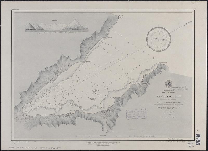
South Pacific Ocean, Samoan Group, Fangaloa Bay (Island of Upolu)
Item Information
- Title:
- South Pacific Ocean, Samoan Group, Fangaloa Bay (Island of Upolu)
- Issuing body:
- United States. Hydrographic Office
- Draftsman:
- Klakring, A. (Alfred)
- Engraver:
- Kübel, S. J. (Stephen J.)
- Engraver:
- Ruebsam, A. C. (Adolph C.)
- Draftsman:
- Wimpffen, L. F. von (Lebreclit Felix von)
- Name on Item:
-
from a survey in 1888 by the officers of the U.S.S. Mohican, Commander B.F. Day, U.S.N. comdg. ; drawn by L.F. von Wimpffen and A. Klakring ; engraved by S.J. Kübel and A.C. Ruebsam
- Date:
-
1888
- Format:
-
Maps/Atlases
- Genre:
-
Nautical charts
- Location:
-
Boston Public Library
Norman B. Leventhal Map & Education Center - Collection (local):
-
Norman B. Leventhal Map & Education Center Collection
- Subjects:
-
Fagaloa Bay (Samoa)--Maps
Navigation--Samoa--Fagaloa Bay
- Places:
-
Samoa
Fagaloa Bay
- Extent:
- 1 map ; 36 x 51 cm
- Terms of Use:
-
No known copyright restrictions.
No known restrictions on use.
- Publisher:
-
Washington, D.C. :
Hydrographic Office
- Edition:
- Edition of September 1888
- Scale:
-
Scale approximately 1:12,300
- Language:
-
English
- Notes:
-
Relief shown by shading and spot heights. Depths shown by soundings and pictorially.
Includes coastal view: Appearance of land looking into the harbor, Malata Peak bearing S. 61° W. (true).
- Identifier:
-
06_01_017649
- Call #:
-
G9096.P5 svar .U55 no. 1136
- Barcode:
-
39999085960977


