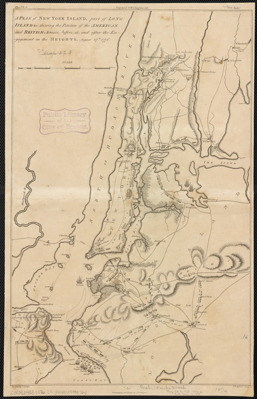
A plan of New York Island, part of Long Island &c. shewing the position of the American and British Armies, before, at, and after the engagement on the Heights, August 27th 1776
This map is also available in American Revolutionary Geographies Online (ARGO), a collections portal especially built for material relating to the American Revolutionary War Era. Visit ARGO to learn more about this item and explore the historical geography of North America in the late eighteenth century.
Item Information
- Title:
- A plan of New York Island, part of Long Island &c. shewing the position of the American and British Armies, before, at, and after the engagement on the Heights, August 27th 1776
- Creator:
- Lewis, Samuel, 1753 or 4-1822
- Name on Item:
-
drawn by S. Lewis ; J.H. Seymour sculp.
- Date:
-
[1776]
- Format:
-
Maps/Atlases
- Location:
-
Boston Public Library
Norman B. Leventhal Map & Education Center - Collection (local):
-
Norman B. Leventhal Map & Education Center Collection
- Subjects:
-
Long Island, Battle of, New York, N.Y., 1776
New York (N.Y.)--History--Revolution, 1775-1783--Maps--Early works to 1800
Long Island (N.Y.)--History--Revolution, 1775-1783--Maps--Early works to 1800
- Places:
-
New YorkLong Island (island)
- Extent:
- 1 map ; 41 x 26 cm.
- Terms of Use:
-
No known copyright restrictions.
No known restrictions on use.
- Publisher:
-
Philadelphia :
C.P. Wayne
- Scale:
-
Scale [ca. 1:95,040].
- Language:
-
English
- Notes:
-
Relief shown by hachures.
"Engraved for Washingtons Life."
In upper left corner: "Plate II."
Shows lines of fire.
- Notes (date):
-
This date is inferred.
- Identifier:
-
06_01_003132
- Call #:
-
G3804.N4S3 1776 .L4
- Barcode:
-
39999058998764


