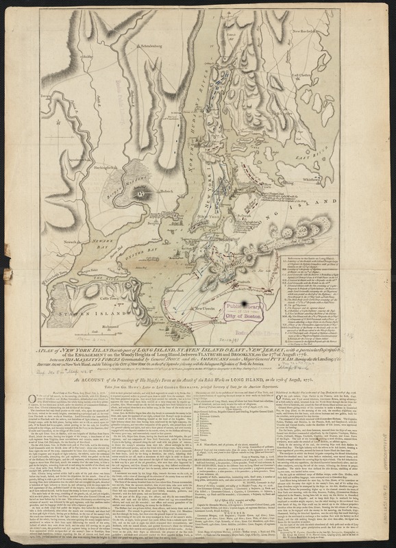
A plan of New York Island, with part of Long Island, Staten Island & east New Jersey, with a particular description of the engagement on the Woody Heights of Long Island, between Flatbush and Brooklyn, on the 27th of August 1776 : between His Majesty's forces commanded by General Howe and the Americans under Major General Putnam, shewing also the landing of the British Army on New-York Island, and the taking of the city of New-York &c. on the 15th of September following, with the subsequent disposition of both the armies
This map is also available in American Revolutionary Geographies Online (ARGO), a collections portal especially built for material relating to the American Revolutionary War Era. Visit ARGO to learn more about this item and explore the historical geography of North America in the late eighteenth century.
Item Information
- Title:
- A plan of New York Island, with part of Long Island, Staten Island & east New Jersey, with a particular description of the engagement on the Woody Heights of Long Island, between Flatbush and Brooklyn, on the 27th of August 1776 : between His Majesty's forces commanded by General Howe and the Americans under Major General Putnam, shewing also the landing of the British Army on New-York Island, and the taking of the city of New-York &c. on the 15th of September following, with the subsequent disposition of both the armies
- Creator:
- Faden, William, 1749-1836
- Name on Item:
-
engraved & publish'd ... by Wm. Faden.
- Date:
-
1776
- Format:
-
Maps/Atlases
- Location:
-
Boston Public Library
Norman B. Leventhal Map & Education Center - Collection (local):
-
Norman B. Leventhal Map & Education Center Collection
- Subjects:
-
Long Island, Battle of, New York, N.Y., 1776--Maps--Early works to 1800
New York (N.Y.)--History--Revolution, 1775-1783--Maps--Early works to 1800
Long Island (N.Y.)--History--Revolution, 1775-1783--Maps--Early works to 1800
Staten Island (New York, N.Y.)--History--18th century--Maps--Early works to 1800
- Places:
-
New YorkRichmond (county)Staten Island (island)
- Extent:
- 1 map : hand col. ; 48 x 43 cm.
- Terms of Use:
-
No known copyright restrictions.
No known restrictions on use.
- Publisher:
-
London :
Wm. Faden
- Scale:
-
Scale [ca. 1:84,000]
- Language:
-
English
- Notes:
-
Relief shown by hachures.
Depths shown by soundings.
Shows information to Sept. 3, 1776.
Below map: An account of the proceedings of His Majesty's forces at the attack of the rebel works on Long Island, on the 27th of August, 1776 : taken from Gen. Howe's letter to Lord George Germaine, principal Secretary of State for the American Department."
State 5 of the map, with Fort Lee or Ft. Constitution added and Younkers unlabeled.
- Identifier:
-
06_01_003140
- Call #:
-
G3802.L6S3 1776 .F3
- Barcode:
-
39999058998848
- LCCN:
-
gm 71000865


