Union Park


Item Information
- Title:
- Union Park
- Description:
-
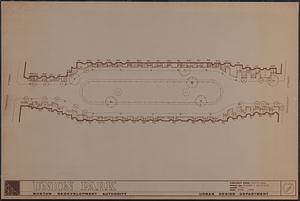
Manuscript map in ink showing trees, bushes, stoops, house numbers, and outline of building facades. A photocopy of the manuscript map has manuscript annotations in pencil.
- Publisher:
- Boston Redevelopment Authority
- Cartographer:
- Erickson, Roger C.
- Name on Item:
-
drawn by Roger C. Erickson ; Boston Redevelopment Authority
- Date:
-
April 1986
- Format:
-
Maps/Atlases
- Genre:
-
Manuscript maps
- Location:
-
Boston Public Library
Norman B. Leventhal Map & Education Center - Collection (local):
-
Norman B. Leventhal Map & Education Center Collection
- Series:
- Boston Redevelopment Authority Maps & Manuscript Plans Collection
- Subjects:
-
City planning--Massachusetts--Boston--Maps
South End (Boston, Mass.)--Maps
- Places:
-
MassachusettsSuffolk (county)BostonSouth End
- Extent:
- 1 manuscript map and 1 photocopy ; sheet 61 x 92 cm
- Terms of Use:
-
No known copyright restrictions.
No known restrictions on use.
- Publisher:
-
[Boston] :
Boston Redevelopment Authority
- Scale:
-
Scale 1:240
- Language:
-
English
- Notes:
-
Oriented with north to the upper left.
- Identifier:
-
06_01_017832A
06_01_017832B
- Call #:
-
BRA MAP FOLDER 13
- Barcode:
-
30000007747785


