East-India Archipelago, Singapore Strait : from British and Dutch surveys, 1865 to 1869 : republication of the British Admty. chart no. 2403, corrected to 1874
Item Information
- Title:
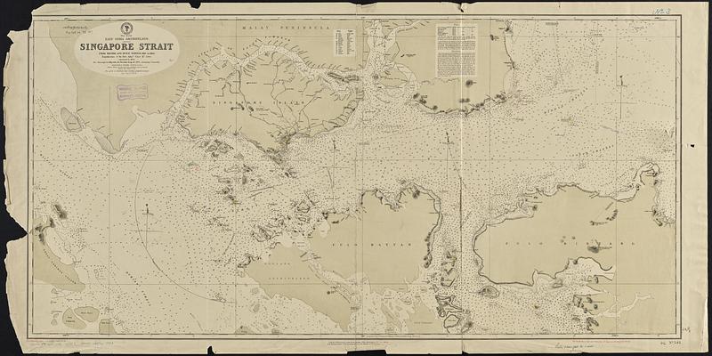
- East-India Archipelago, Singapore Strait : from British and Dutch surveys, 1865 to 1869 : republication of the British Admty. chart no. 2403, corrected to 1874
- Issuing body:
- United States. Hydrographic Office
- Date:
-
[1887]
- Format:
-
Maps/Atlases
- Genre:
-
Nautical charts
- Location:
-
Boston Public Library
Norman B. Leventhal Map & Education Center - Collection (local):
-
Norman B. Leventhal Map & Education Center Collection
- Subjects:
-
Singapore Strait--Maps
Nautical charts--Singapore Strait
- Places:
-
Singapore Strait
- Extent:
- 1 map ; 57 x 117 cm
- Terms of Use:
-
No known copyright restrictions.
No known restrictions on use.
- Publisher:
-
Washington, D.C. :
Hydrographic Office
- Scale:
-
Scale approximately 1:125,000
- Language:
-
English
- Notes:
-
Relief shown by hachures and spot heights. Depths shown by soundings, isolines and pictorially.
Includes glossary, tides and directions.
Manuscript additions and corrections in red ink.
Manuscript in red ink in lower margin: Cor. (19.II.83.)(1993.3.9.12.16.)(1887.25.43. -- Cor. VII.85. -- Cor. 41.III.80.)(106.VII.80.)(31.IV.81.)(52.IV.82.)(67.IV.83.).
- Notes (date):
-
This date is inferred.
- Identifier:
-
06_01_017686
- Call #:
-
G9096.P5 svar .U55 no. 543
- Barcode:
-
39999085961983


