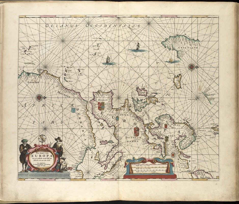
Pas-kaart van Europa met een gedeelte van de kust van Africa tot aen Cabo Verde
Item Information
- Title:
- Pas-kaart van Europa met een gedeelte van de kust van Africa tot aen Cabo Verde
- Creator:
- Doncker, Hendrick, 1626-1699
- Name on Item:
-
By Hendrick Doncker inde nieubrugsteegh.
- Date:
-
1665
- Format:
-
Maps/Atlases
- Location:
-
Boston Public Library
Norman B. Leventhal Map & Education Center - Collection (local):
-
Norman B. Leventhal Map & Education Center Collection
- Subjects:
-
Europe--Maps--Early works to 1800
- Places:
-
Europe
Europe
- Extent:
- 1 map : col. ; 42 x 52 cm.
- Terms of Use:
-
No known copyright restrictions.
No known restrictions on use.
- Publisher:
-
Amsterdam :
Hendrick Doncker
- Scale:
-
Scale ca. 1;14,000,000.
- Language:
-
Dutch
- Notes:
-
Map of Europe with the coast of Africa and Cape Verde.
Oriented with north to the right.
Includes coats of arms, illustations, and an elaborate cartouche.
From the author's Zee-atlas of Water-waerelt. Amsterdam: By Hendrik Doncker, boeckverkooper, en graat-boog-maker, in de Nieuwe-brug-steegh, in 't Stuurmans Gereetschap, Anno 1660 [i.e. 1665].
Cataloging, conservation, and digitization made possible in part by The National Endowment for the Humanities: Exploring the human endeavor.
Atlas scanned by Internet Archive http://archive.org/details/dezeeatlasofwate00donc
- Identifier:
-
06_01_007866
- Call #:
-
G1059 .D66 1665
- Barcode:
-
30000003764962