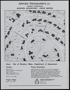
Newton, Mass. parcel mapping project
Item Information
- Title:
- Newton, Mass. parcel mapping project
- Cartographer:
- Applied Geographics, Inc.
- Date:
-
1993
- Format:
-
Maps/Atlases
- Location:
-
Boston Public Library
Norman B. Leventhal Map & Education Center - Collection (local):
-
Applied Geographics, Inc. Records
- Subjects:
-
Newton (Mass.)--Maps
Real property--Massachusetts--Newton--Maps
Land use--Massachusetts--Newton--Maps
Dwellings--Massachusetts--Newton--Maps
Income--Massachusetts--Newton--Maps
- Places:
-
MassachusettsMiddlesex (county)Newton
- Extent:
- 15 maps : color ; sheets 28 x 22 cm and 44 x 28 cm
- Terms of Use:
-
No known copyright restrictions.
No known restrictions on use.
- Publisher:
-
Boston :
Applied Geographics, Inc.
- Language:
-
English
- Notes:
-
Maps show parcels, building footprints, land use, water-pipes, age of residential structures, house styles, open space, and family income levels.
- Identifier:
-
06_01_019028
- Call #:
-
AppGeo Folder 18