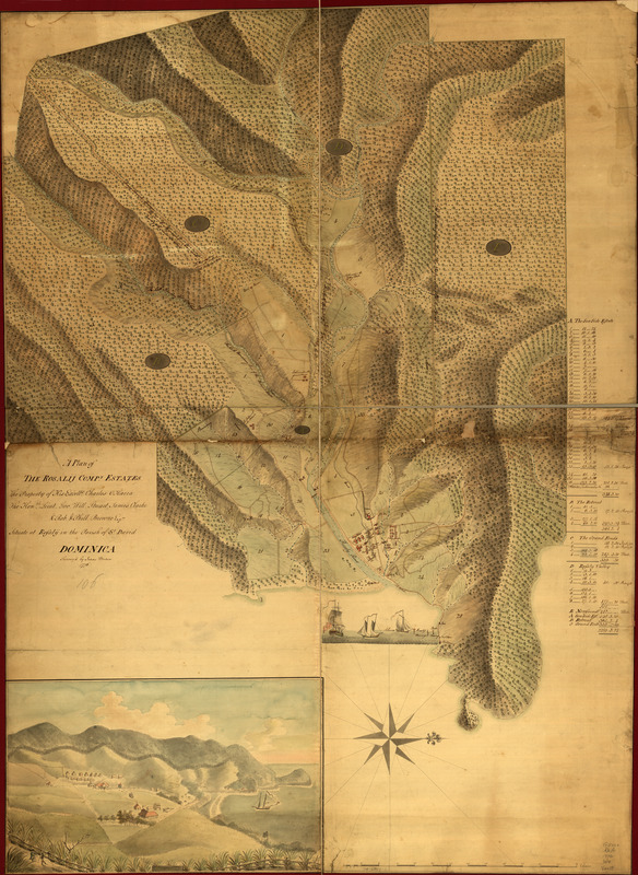
A Plan of the Rosalij Compy. Estates : the property of His Excelly. Charles O'Harra, the Honble. Leiut. Gov. Will. Stuart, James Clarke & Rob. & Phill. Browne, Esqrs., situated at Rosalij in the parish of St. David, Dominica
This map is also available in American Revolutionary Geographies Online (ARGO), a collections portal especially built for material relating to the American Revolutionary War Era. Visit ARGO to learn more about this item and explore the historical geography of North America in the late eighteenth century.
Item Information
- Title:
- A Plan of the Rosalij Compy. Estates : the property of His Excelly. Charles O'Harra, the Honble. Leiut. Gov. Will. Stuart, James Clarke & Rob. & Phill. Browne, Esqrs., situated at Rosalij in the parish of St. David, Dominica
- Title (alt.):
-
Rosalij Compy. Estates
- Name on Item:
-
Survey'd by Isaac Werden. 1776
- Date:
-
[1776]
- Format:
-
Maps/Atlases
Manuscripts
- Location:
- Library of Congress Geography and Map Division
- Collection (local):
-
Library of Congress Collection
- Subjects:
-
Rosalie Region, Dominica--Maps, Manuscript--Early works to 1800
- Places:
-
Rosalie
- Extent:
- 1 manuscript map : hand color, 125 x 92 cm.
- Terms of Use:
-
No known copyright restrictions.
This work is licensed for use under a Creative Commons Attribution Non-Commercial Share Alike License (CC BY-NC-SA).

- Scale:
-
Scale ca. 1:3,960
- Language:
-
English
- Catalog Record:
-
https://lccn.loc.gov/74695802
- Notes:
-
Manuscript, pen-and-ink and watercolor.
Watermark: J. Whatman: C. [and a fleur-de-lis on a crowned shield, over the letters GR]
Relief shown by shading.
Oriented with north to the right.
Pictorial map.
Annotated under title: 106.
Includes index and view inset of "Rosalij."
- Notes (date):
-
This date is inferred.
- Notes (citation):
-
LC Luso-Hispanic World, 379
- Identifier:
-
ct000290z


