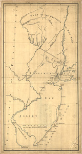
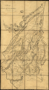
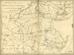
Three maps [i.e. map on 3 sheets] of northern New Jersey, with reference to the boundary between New York and New Jersey
![Three maps [i.e. map on 3 sheets] of northern New Jersey, with reference to the boundary between New York and New Jersey](https://bpldcassets.blob.core.windows.net/derivatives/images/commonwealth:q524nk04q/image_access_800.jpg)
This map is also available in American Revolutionary Geographies Online (ARGO), a collections portal especially built for material relating to the American Revolutionary War Era. Visit ARGO to learn more about this item and explore the historical geography of North America in the late eighteenth century.
Item Information
- Title:
- Three maps [i.e. map on 3 sheets] of northern New Jersey, with reference to the boundary between New York and New Jersey
- Title (alt.):
-
Three maps of northern New Jersey, with reference to the boundary between New York and New Jersey
- Date:
-
[1769?]
- Format:
-
Maps/Atlases
Manuscripts
- Location:
- Library of Congress Geography and Map Division
- Collection (local):
-
Library of Congress Collection
- Subjects:
-
New Jersey--Boundaries--New York (State)--Maps, Manuscript--Early works to 1800
New York (State)--Boundaries--New Jersey--Maps, Manuscript--Early works to 1800
New Jersey--Maps, Manuscript--Early works to 1800
- Places:
-
New York
New Jersey
- Extent:
- 1 manuscript map : hand color, on 3 sheets 61 x 59 cm. or smaller mounted on 2 sheets.
- Terms of Use:
-
No known copyright restrictions.
This work is licensed for use under a Creative Commons Attribution Non-Commercial Share Alike License (CC BY-NC-SA).

- Scale:
-
Scale ca. 1:180,000
- Language:
-
English
- Catalog Record:
-
https://lccn.loc.gov/gm71000590
- Notes:
-
Title from William Faden's Catalogue of a curious and valuable collection of original maps and plans. Boston, 1862.
Manuscript, pen-and-ink and watercolor.
Relief shown by hachures and shading.
Imperfect: Edges torn.
Shows roads, county and township boundaries, land grants, the division line between East and West Jersey, 5 different proposed division lines between New Jersey and New York by separate claims and surveys, and part of long island.
- Notes (citation):
-
LC Maps of North America, 1750-1789, 1245
- Identifier:
-
ar124500z