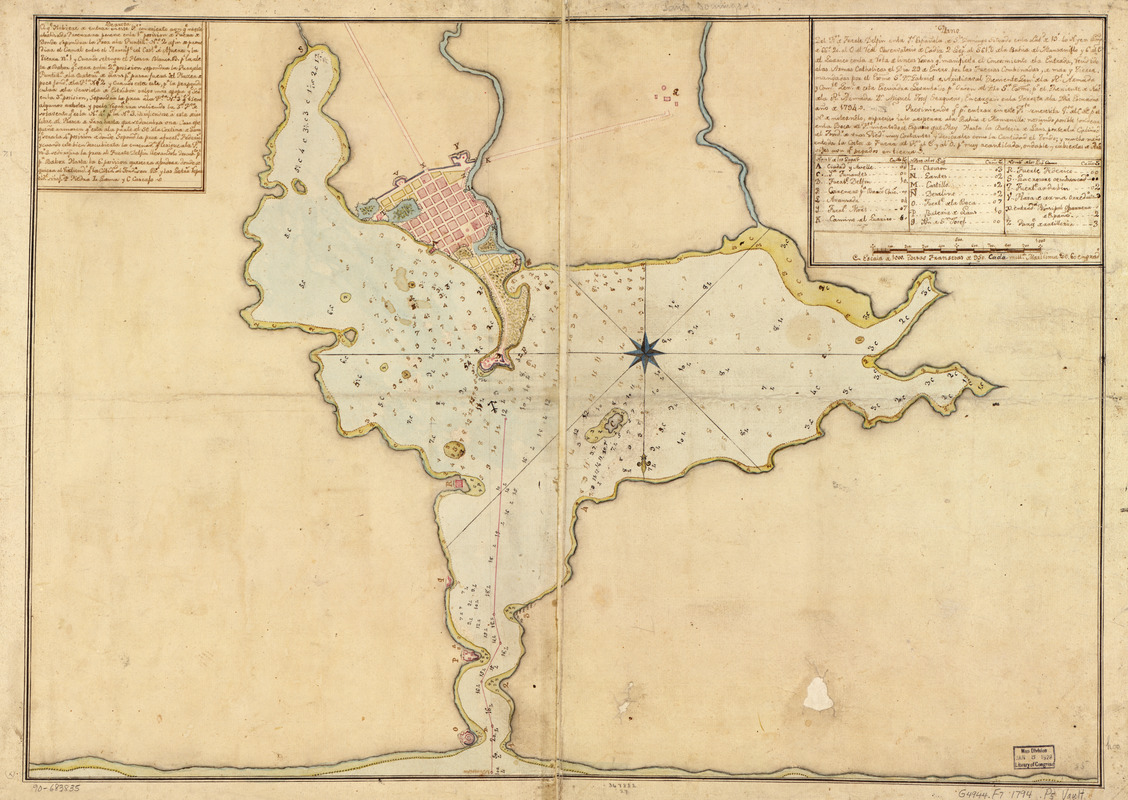
Plano del pto. de Fuerte Delfin en la Ys. Española de Sto. Domingo situado en la latd. de 19⁰40ʹ N. y en longd. de 66⁰20ʹ al O. del veal observatorio de Cádiz, 2 legs. al S. 61⁰ O. del a Bahía del Manzanillo y 6 al E. del Guárico con la de vota de líneas voxas qe. manifiesta a el conosimiento del a entrada, vendido alas Armas Catholicas el día 29 de enero por las fuerias combinadar, de mar y tierra mandadas por el Exmo. Sr. Dn. Gabriel de Aristisaval, theniente genl. de la Rl. Armada y comte. genl. de esta escuadra levantado pr. orden del Dho. Sr. Exmo., pr. el theniente de Navo. de la Rl. Armada Dn. Miguel Josef Serquero, encargado en la derrota de la dha. escuadra, año de 1794
This map is also available in American Revolutionary Geographies Online (ARGO), a collections portal especially built for material relating to the American Revolutionary War Era. Visit ARGO to learn more about this item and explore the historical geography of North America in the late eighteenth century.
Item Information
- Title:
- Plano del pto. de Fuerte Delfin en la Ys. Española de Sto. Domingo situado en la latd. de 19⁰40ʹ N. y en longd. de 66⁰20ʹ al O. del veal observatorio de Cádiz, 2 legs. al S. 61⁰ O. del a Bahía del Manzanillo y 6 al E. del Guárico con la de vota de líneas voxas qe. manifiesta a el conosimiento del a entrada, vendido alas Armas Catholicas el día 29 de enero por las fuerias combinadar, de mar y tierra mandadas por el Exmo. Sr. Dn. Gabriel de Aristisaval, theniente genl. de la Rl. Armada y comte. genl. de esta escuadra levantado pr. orden del Dho. Sr. Exmo., pr. el theniente de Navo. de la Rl. Armada Dn. Miguel Josef Serquero, encargado en la derrota de la dha. escuadra, año de 1794
- Date:
-
[1794]
- Format:
-
Maps/Atlases
Manuscripts
- Location:
- Library of Congress Geography and Map Division
- Collection (local):
-
Library of Congress Collection
- Subjects:
-
Fort Liberté (Haiti)--Maps, Manuscript--Early works to 1800
Harbors--Haiti--Fort Liberté--Maps--Early works to 1800
Manuscript maps--Early works to 1800
- Places:
-
HaitiNord-EstFort Liberte
- Extent:
- 1 map : ms., col. ; 47 x 67 cm.
- Terms of Use:
-
No known copyright restrictions.
This work is licensed for use under a Creative Commons Attribution Non-Commercial Share Alike License (CC BY-NC-SA).

- Scale:
-
Scale [ca. 1:17,500]
- Language:
-
Spanish
- Catalog Record:
-
https://lccn.loc.gov/90683835
- Notes:
-
Depths shown by soundings.
Prime meridian: Cádiz.
Oriented with north to the bottom.
Watermarks: IV, J. Kool, and fleur-de-lis.
Pen-and-ink and watercolor.
Mounted on cloth backing.
Includes text and index.
Printed label describing the map mounted on verso.
Maggs number annotated in pencil in lower right corner: 85.
Order number annotated in pencil in lower margin: 367882/27.
- Notes (date):
-
This date is inferred.
- Notes (citation):
-
LC Luso-Hispanic World, 461
- Identifier:
-
lh000461


