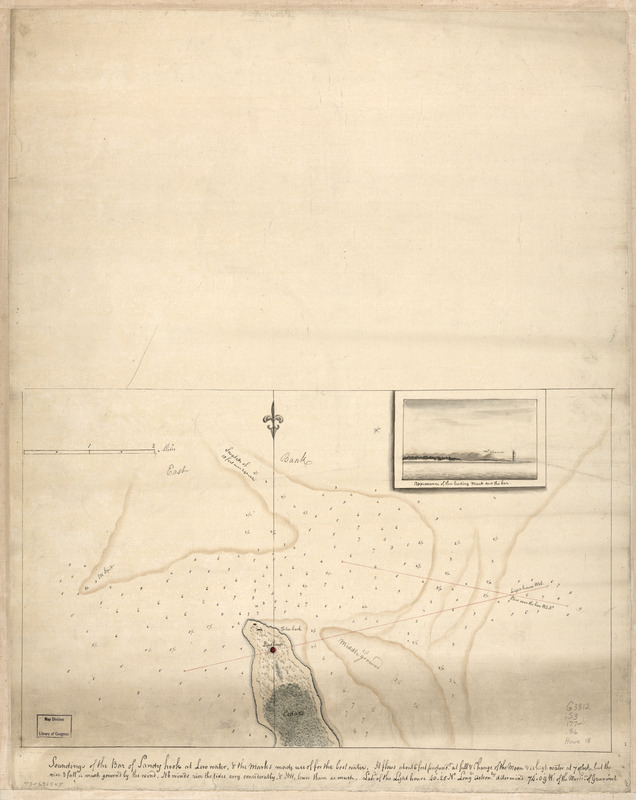
Soundings of the bar of Sandy Hook at low water & the marks made use of for the best water
This map is also available in American Revolutionary Geographies Online (ARGO), a collections portal especially built for material relating to the American Revolutionary War Era. Visit ARGO to learn more about this item and explore the historical geography of North America in the late eighteenth century.
Item Information
- Title:
- Soundings of the bar of Sandy Hook at low water & the marks made use of for the best water
- Date:
-
[1770?–1779?]
- Format:
-
Maps/Atlases
Manuscripts
- Location:
- Library of Congress Geography and Map Division
- Collection (local):
-
Library of Congress Collection
- Subjects:
-
Sandy Hook (N.J.)--Maps, Manuscript--Early works to 1800
- Places:
-
Monmouth (county)Sandy Hook (cape)
- Extent:
- 1 manuscript map : hand color 28 x 46 cm. on sheet 61 x 49 cm.
- Terms of Use:
-
No known copyright restrictions.
This work is licensed for use under a Creative Commons Attribution Non-Commercial Share Alike License (CC BY-NC-SA).

- Scale:
-
Scale ca. 1:31,500
- Language:
-
English
- Catalog Record:
-
https://lccn.loc.gov/73691545
- Notes:
-
Depths shown by soundings.
Title on verso: Sandy Hook, 133.
Manuscript, pen-and-ink and watercolor.
Watermark: J. Whatman.
Prime meridian: Greenwich.
Inset view: Appearance of the leading mark over the bar.
- Notes (citation):
-
LC Maps of North America, 1750-1789, 1292
- Identifier:
-
ar129200


