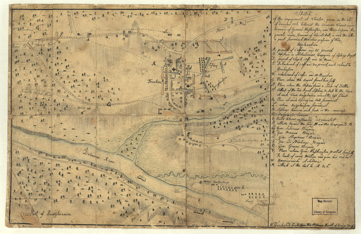
Sketch of the engagement at Trenton : given on the 26th of December 1776 betwixt the American troops under command of General Washington, and three Hessian regiments under command of Colonell Rall, in which the latter a part surrendert themselves prisoner of war
This map is also available in American Revolutionary Geographies Online (ARGO), a collections portal especially built for material relating to the American Revolutionary War Era. Visit ARGO to learn more about this item and explore the historical geography of North America in the late eighteenth century.
Item Information
- Title:
- Sketch of the engagement at Trenton : given on the 26th of December 1776 betwixt the American troops under command of General Washington, and three Hessian regiments under command of Colonell Rall, in which the latter a part surrendert themselves prisoner of war
- Creator:
- Wiederholdt, Andreas, 1752?-
- Name on Item:
-
[By] Wiederhold Lieut: from the Hessian Rgmt of Knÿphauss
- Date:
-
[1776?]
- Format:
-
Maps/Atlases
Manuscripts
- Location:
- Library of Congress Geography and Map Division
- Collection (local):
-
Library of Congress Collection
- Subjects:
-
Trenton, Battle of, Trenton, N.J., 1776--Maps, Manuscript--Early works to 1800
Trenton (N.J.)--Early works to 1800
- Places:
-
Mercer (county)Trenton
- Extent:
- 1 manuscript map : hand color; 23 x 28 cm.
- Terms of Use:
-
No known copyright restrictions.
This work is licensed for use under a Creative Commons Attribution Non-Commercial Share Alike License (CC BY-NC-SA).

- Scale:
-
Scale not given
- Language:
-
English
- Catalog Record:
-
https://lccn.loc.gov/gm71002184
- Notes:
-
Manuscript, pen-and-ink and watercolor.
Relief shown by hachures.
Includes "Explanation."
- Notes (citation):
-
LC Maps of North America, 1750-1789, 1267
- Identifier:
-
ar126700