Boston Over Time : filling in the land 1630 - present
Item Information
- Title:
- Boston Over Time : filling in the land 1630 - present
- Description:
-
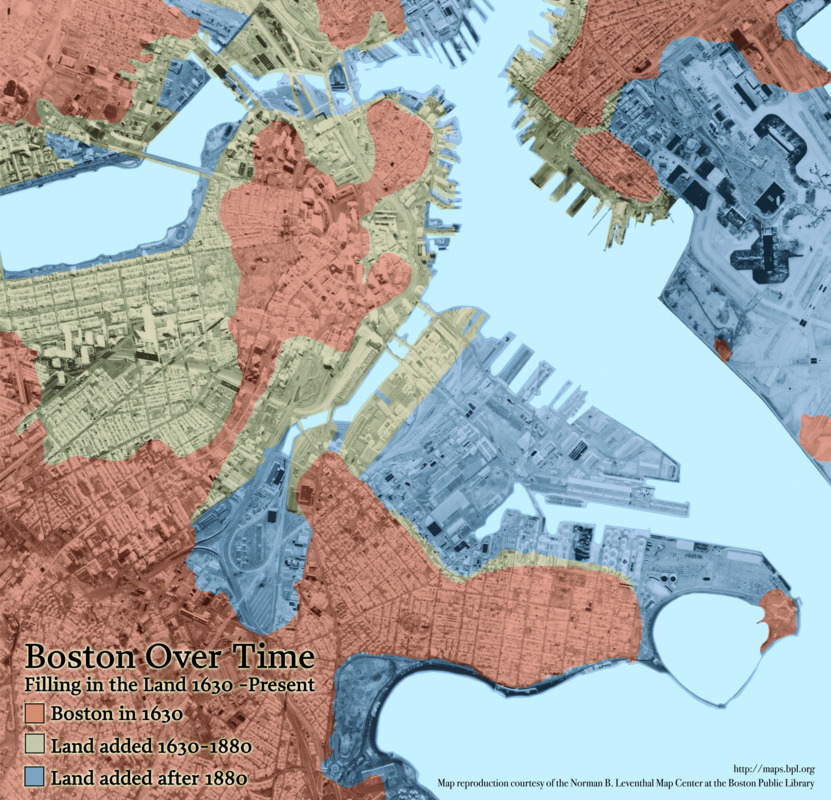
Beneath Our Feet: This modern map illustrates the various "land making" projects that have shaped Boston over the past three centuries, along with locations where the five artifacts on display here were unearthed. The pink landmass represents the original Shawmut Peninsula and mainland region, where Native Americans dwelled for millennia, and where Puritan colonists settled in 1630. The tan area represents land made from the 17th-19th centuries, while the blue indicates the most recent additions. Four of the artifacts were found in the oldest landmasses, while the fifth artifact – the fishweir stakes – was found in what was water thousands of years ago.
- Cartographer:
- Chan Krieger & Associates
- Date:
-
2008
- Format:
-
Maps/Atlases
- Location:
-
Boston Public Library
Norman B. Leventhal Map & Education Center - Collection (local):
-
Norman B. Leventhal Map & Education Center Collection
- Subjects:
-
Boston (Mass.)--Historical geography--Maps
- Places:
-
MassachusettsSuffolk (county)Boston
- Extent:
- 1 map : color
- Terms of Use:
-
No known copyright restrictions.
No known restrictions on use.
- Language:
-
English
- Notes:
-
Shows Boston in 1630, 1880 and 2009.
Created for the Boston and Beyond exhibition at the Norman B. Leventhal Map Center, 2008.
- Notes (exhibitions):
-
Exhibited: "Beneath Our Feet: Mapping the World Below" organized by the Norman B. Leventhal Map Center at the Boston Public Library, 2017-2018.
Exhibited: "Regions and Seasons: Mapping Climate through History" organized by the Norman B. Leventhal Map Center at the Boston Public Library, 2017.
- Identifier:
-
BostonOverTime


