Les tables de geographie, reduites en un jeu de cartes
Item Information
- Title:
- Les tables de geographie, reduites en un jeu de cartes
- Title (alt.):
-
Tables de geographie, reduites en vn iev de cartes
- Description:
-
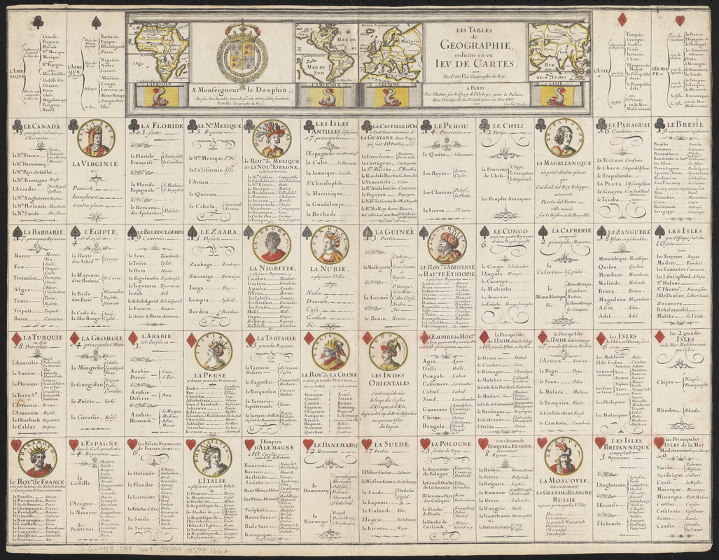
Sheet of 52 cartographic playing cards, with 13 each of 4 suits (hearts, diamonds, spades and clubs). Each suit is assigned to a continent or continents (hearts to Europe, diamonds to Asia, spades to Africa and clubs to the Americas) and contains 3 face cards, each with medallion portrait, and 10 numbered cards (ace through ten), each with a list of facts about a nation or region on that continent. At head of sheet are four small continental maps: "L'Afrique" and "L'Amerique" flanking a dedication to Louis, Dauphin of France (1661-1711); "L'Europe" and "L'Asie" flanking the title.
- Creator:
- Duval, P. (Pierre), 1619-1682
- Author:
- Duval, P. (Pierre), 1619-1682
- Engraver:
- Cordier, Robert, (Engraver)
- Name on Item:
-
par P. Du-Val, geographe du Roy ; Cordier sculp.
- Date:
-
1669
- Format:
-
Maps/Atlases
- Location:
-
Boston Public Library
Norman B. Leventhal Map & Education Center - Collection (local):
-
Norman B. Leventhal Map & Education Center Collection
- Subjects:
-
Geographical recreations--Early works to 1800
Card games--Early works to 1800
Geography--Early works to 1800
Playing cards--Specimens--Early works to 1800
- Extent:
- 1 sheet : hand color illustrations, hand color maps ; 42 x 54 cm
- Terms of Use:
-
No known copyright restrictions.
No known restrictions on use.
- Publisher:
-
A Paris :
Chez l'auteur
- Language:
-
French
- Notes:
-
A Paris. Chez l'Auteur sur le Quay de l'Orloge, pres le Palais; Avec privilege de Sa Maïesté, pour 20. Ans. 1669.
Red suits (hearts and diamonds) hand-colored; hand-colored maps.
"A Monseigneur le Dauphin, par son tres-humble, tres-obeissant, et tres-fidele serviteur, P. du Val, Geographe du Roy."
- Notes (citation):
-
IMCoS, number 122, pages 15-23
- Identifier:
-
06_01_016030
- Call #:
-
GV1485 .D88 1669
- Barcode:
-
39999085941662
![Quam hic vides orbis imagine[m] lector ca[n]dide ea[m] ut posteriore[m] ita & eme[n]datiorem ijs que hactenus circu[m]ferebantur esse America sarmatiaq[ue] ac India testantur ... lemei expectato vale](https://bpldcassets.blob.core.windows.net/derivatives/images/commonwealth:3f463b69r/image_thumbnail_300.jpg)


