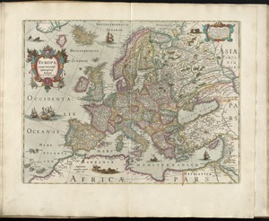
Bowles's new and accurate map of Europe, divided into it's [sic] empires, kingdoms, states, republicks and principalities : laid down from surveys and observations, of the most celebrated geographers ; corrected from late remarks, with many additions and valuable modern improvements
![Bowles's new and accurate map of Europe, divided into it's [sic] empires, kingdoms, states, republicks and principalities](https://bpldcassets.blob.core.windows.net/derivatives/images/commonwealth:q524mt678/image_access_800.jpg)
Item Information
- Title:
- Bowles's new and accurate map of Europe, divided into it's [sic] empires, kingdoms, states, republicks and principalities : laid down from surveys and observations, of the most celebrated geographers ; corrected from late remarks, with many additions and valuable modern improvements
- Creator:
- Bowles, Carington, 1724-1793
- Date:
-
1785
- Format:
-
Maps/Atlases
- Location:
- George Washington's Mount Vernon
- Collection (local):
-
Richard H. Brown Revolutionary War Map Collection at Mount Vernon
- Subjects:
-
Europe--Maps--Early works to 1800
- Places:
-
Europe
Europe
- Extent:
- 1 map : hand col. ; 98 x 103 cm.
- Terms of Use:
-
No known copyright restrictions.
This work is licensed for use under a Creative Commons Attribution Non-Commercial Share Alike License (CC BY-NC-SA).

- Publisher:
-
London :
Carington Bowles
- Scale:
-
Scale [ca. 1:4,900,000]
- Language:
-
English
- Catalog Record:
-
MVLA record
- Notes:
-
Relief shown pictorially.
"Tables shewing the general divisions of Europe into it's [sic] several empires, kingdoms, and states" in left and right margins.
- Identifier:
-
06_01_009603
- Barcode:
-
30000003873511