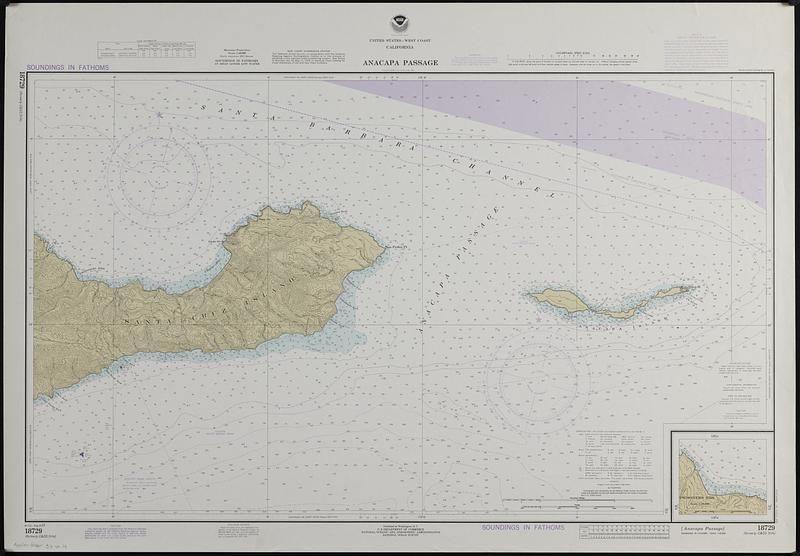
United States--west coast, California, Anacapa Passage
Item Information
- Title:
- United States--west coast, California, Anacapa Passage
- Cartographer:
- National Ocean Survey
- Name on Item:
-
National Ocean Survey
- Date:
-
1977
- Format:
-
Maps/Atlases
- Location:
-
Boston Public Library
Norman B. Leventhal Map & Education Center - Collection (local):
-
Applied Geographics, Inc. Records
- Subjects:
-
Anacapa Passage (Calif.)--Navigation
Santa Barbara Channel (Calif.)--Navigation
Pacific Coast (Calif.)--Maps
North Pacific Ocean--Navigation
- Places:
-
CaliforniaVentura (county)Anacapa Island (island)
CaliforniaSanta Barbara (county)Santa Cruz Island (island)
Anacapa Passage
Santa Barbara Channel
- Extent:
- 1 map : color ; 54 x 91 cm on sheet 69 x 99 cm
- Terms of Use:
-
No known copyright restrictions.
No known restrictions on use.
- Publisher:
-
Washington, D.C. :
U.S. Department of Commerce, National Oceanic and Atmospheric Administration, National Ocean Survey
- Edition:
- 8th ed., Aug. 20/77.
- Scale:
-
Scale 1:40,000
- Projection:
- Mercator projection
- Language:
-
English
- Notes:
-
Depths shown by isolines and soundings.
Relief shown by contours and spot heights.
"Soundings in fathoms."
Inset: Prisoners Hbr. Scale 1:20,000.
Includes tidal information, abbreviations information, notes, and logarithmic speed scale.
"18729 (formerly C&GS 5114)."
- Identifier:
-
06_01_019100
- Call #:
-
AppGeo Folder 33 no.14