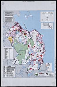
Town of Plymouth [land development planning]
![Town of Plymouth [land development planning]](https://bpldcassets.blob.core.windows.net/derivatives/images/commonwealth:tt44v120f/image_access_800.jpg)
Item Information
- Title:
- Town of Plymouth [land development planning]
- Cartographer:
- Applied Geographics, Inc.
- Contributor:
- MassGIS (Office : Mass.)
- Name on Item:
-
Applied Geographics, Inc.
- Date:
-
1999
- Format:
-
Maps/Atlases
- Genre:
-
Thematic maps
- Location:
-
Boston Public Library
Norman B. Leventhal Map & Education Center - Collection (local):
-
Applied Geographics, Inc. Records
- Subjects:
-
Plymouth (Mass. : Town)--Maps
Zoning--Massachusetts--Plymouth (Town)--Maps
Land use--Massachusetts--Plymouth (Town)--Maps
Real estate development--Massachusetts--Plymouth (Town)--Maps
City planning--Massachusetts--Plymouth (Town)--Maps
- Places:
-
MassachusettsPlymouth (county)Plymouth
- Extent:
- 3 maps : color ; 34 x 26 cm
- Terms of Use:
-
No known copyright restrictions.
No known restrictions on use.
- Publisher:
-
Boston :
Applied Geographics, Inc.
- Scale:
-
Scale 1:20,400. 1 inch equals 1,700 feet
- Language:
-
English
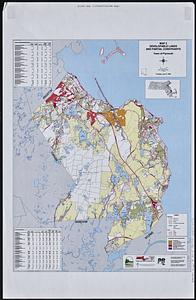
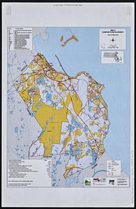
- Table of Contents:
-
Map 1. Zoning and absolute development contraints
Map 2. Developable lands and partial constraints
Map 3. Composite development.
- Identifier:
-
06_01_018913A
06_01_018913B
06_01_018913C
- Call #:
-
AppGeo Folder 3 no. 4-6
- Barcode:
-
30000008056473