Plan des catacombes de Syracuse ; intérieur d'une des chambres sépulcrales des catacombes
Item Information
- Title:
- Plan des catacombes de Syracuse ; intérieur d'une des chambres sépulcrales des catacombes
- Title (alt.):
-
Intérieur d'une des chambres sépulcrales des catacombes
- Description:
-
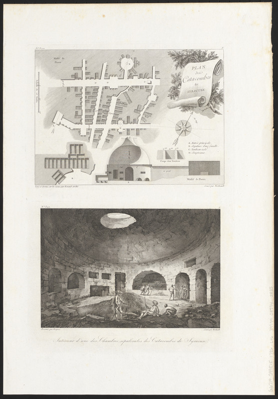
Syracuse, the main city of classical Sicily, was settled by the Corinthians in the 8th century BCE. By the 2nd century CE, Syracuse was under Roman control, and it was during this time that the first burials took place in the area now known as the Catacombs of San Giovanni. Displayed here in this late 18th-century print, the catacomb complex is believed to have been built upon existing aqueducts and cisterns used by ancient Syracuse residents. The map illustrates the pathways in the underground complex, along with large open spaces called rotundas and their occuli, or skylights, while the scene below depicts an expedition in the sepulcher.
- Cartographer:
- Renard, Jean Augustin, 1744-1807
- Engraver:
- Berthault, Pierre Gabriel, 1737-1831
- Artist:
- Desprez, Louis-Jean, 1743-1804
- Name on Item:
-
levé et dessiné sur les lieux par Renard Archit. ; gravé par Bertheault ; dessinée par Desprez ; gravé par Berthault
- Date:
-
[1786]
- Format:
-
Maps/Atlases
- Location:
-
Boston Public Library
Norman B. Leventhal Map & Education Center - Collection (local):
-
Norman B. Leventhal Map & Education Center Collection
- Subjects:
-
Catacombs--Italy--Syracuse--Maps--Early works to 1800
Catacombs--Italy--Syracuse--Pictorial works--Early works to 1800
Syracuse (Italy)--Maps--Early works to 1800
- Places:
-
ItalySicily (region)Siracusa (province)Syracuse
- Extent:
- 1 map and 1 illustration on 1 sheet ; 17 x 24 cm and 15 x 23 cm, on sheet 49 x 34 cm
- Terms of Use:
-
No known copyright restrictions.
No known restrictions on use.
- Publisher:
-
[Paris] :
[Imprimerie de Clousier]
- Scale:
-
Scale approximately 1:600
- Language:
-
French
- Notes:
-
Map and illustration of the Catacombs of San Giovanni.
From Jean Claude Richard de Saint Non's Voyage pittoresque ou description des royaumes de Naples et de Sicile, quatrième volume, seconde partie (Paris : Imprimerie de Clousier, 1786).
Map oriented with north to the upper right.
Map includes 4 illustrations.
In upper left of map: No. 520.
In upper left of illustration: No. 521.
- Notes (date):
-
This date is inferred.
- Notes (exhibitions):
-
Exhibited: "Beneath Our Feet: Mapping the World Below" organized by the Norman B. Leventhal Map Center at the Boston Public Library, 2017-2018.
Exhibited: "Beneath Our Feet" organized by the Norman B. Leventhal Map Center at the Boston Public Library, 2017.
- Identifier:
-
06_01_016076
- Call #:
-
G6714.S99E15 1786 .R46
- Barcode:
-
39999085942835


