Mediterranean Sea, Strait of Messina : from French and British surveys, corrected to 1871
Item Information
- Title:
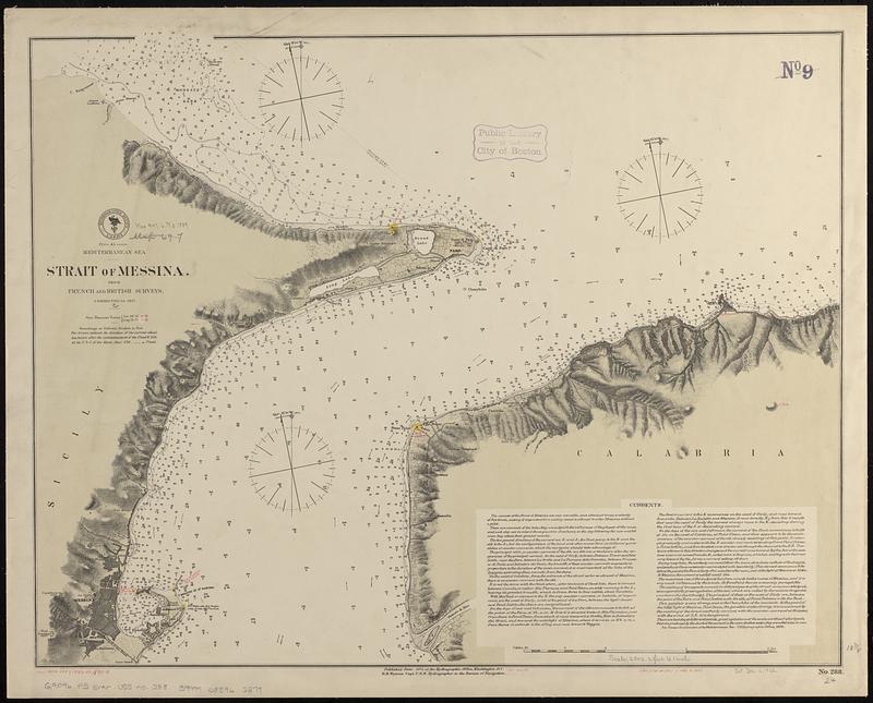
- Mediterranean Sea, Strait of Messina : from French and British surveys, corrected to 1871
- Issuing body:
- United States. Hydrographic Office
- Date:
-
[1889]
- Format:
-
Maps/Atlases
- Genre:
-
Nautical charts
- Location:
-
Boston Public Library
Norman B. Leventhal Map & Education Center - Collection (local):
-
Norman B. Leventhal Map & Education Center Collection
- Subjects:
-
Messina, Strait of (Italy)--Maps
Nautical charts--Italy--Messina, Strait of
- Places:
-
ItalySicily (region)Messina (province)Messina, Stretto di (strait)
- Extent:
- 1 map ; 48 x 62 cm
- Terms of Use:
-
No known copyright restrictions.
No known restrictions on use.
- Publisher:
-
Washington, D.C. :
Hydrographic Office
- Scale:
-
Scale approximately 1:30,000
- Language:
-
English
- Table of Contents:
-
The west side of Gaspar Rico Reef (Smyth or Farnham's Island)
Smith, Johnston or Cornwallis Island
- Notes:
-
Relief shown by hachures and spot heights. Depths shown by soundings and isolines.
Includes text about currents.
Manuscript additions and corrections in red ink.
Manuscript in red ink in lower margin: Cor. (1884.326)(1888.52.)(89-4. -- Cor. XII.72. -- Cor. (36.III.82.)(166.X.83.).
- Notes (date):
-
This date is inferred.
- Identifier:
-
06_01_017658
- Call #:
-
G9096.P5 svar .U55 no. 288
- Barcode:
-
39999085962379


