Mediterranean, anchorages on the east coast of Spain : from Spanish government surveys of 1878
Item Information
- Title:
- Mediterranean, anchorages on the east coast of Spain : from Spanish government surveys of 1878
- Issuing body:
- United States. Hydrographic Office
- Date:
-
1887
- Format:
-
Maps/Atlases
- Genre:
-
Nautical charts
- Location:
-
Boston Public Library
Norman B. Leventhal Map & Education Center - Collection (local):
-
Norman B. Leventhal Map & Education Center Collection
- Subjects:
-
Cullera (Spain)--Maps
Benicásim (Spain)--Maps
Denia (Spain)--Maps
Columbretes Islands (Spain)--Maps
Navigation--Spain--Cullera
Navigation--Spain--Benicásim
Navigation--Spain--Denia
Navigation--Spain--Columbretes Islands
- Places:
-
SpainValencian Community (region)Valencia (province)Cullera
SpainValencian Community (region)Alicante (province)Denia
SpainValencian Community (region)Castellón (province)Columbretes, Islas (area)
SpainValencian Community (region)Castellón (province)Benicasim
- Extent:
- 4 maps on 1 sheet ; 43 x 31 cm
- Terms of Use:
-
No known copyright restrictions.
No known restrictions on use.
- Publisher:
-
Washington, D.C. :
Hydrographic Office
- Edition:
- Edition of September 1887
- Scale:
-
Scale approximately 1:19,700
Scale approximately 1:19,800
Scale approximately 1:26,200
Scale approximately 1:51,800
- Language:
-
English
- Table of Contents:
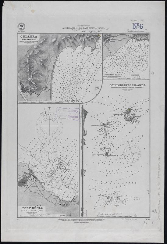
-
Cullera anchorage
Benicasim Road
Port Dénia
Columbretes Islands.
- Notes:
-
Relief shown by hachures and spot heights. Depths shown by soundings and isolines.
Includes coastal view of the Columbretes Islands.
- Identifier:
-
06_01_017714
- Call #:
-
G9096.P5 svar .U55 no. 143
- Barcode:
-
39999085962262


