Atlas of the city of Boston : city proper and Roxbury : plate 12
Item Information
- Title:
- Atlas of the city of Boston : city proper and Roxbury : plate 12
- Description:
-
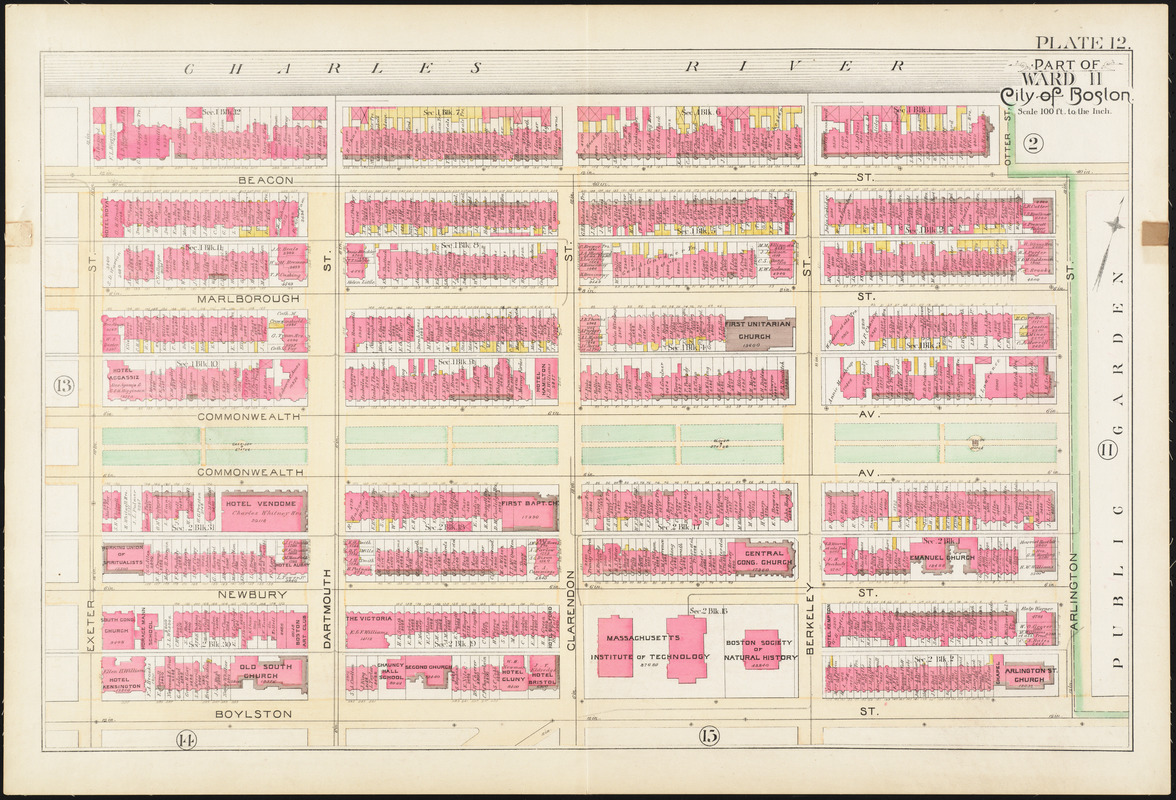
Providing the link between the Public Garden and the Emerald Necklace, the Commonwealth Avenue Mall was Boston’s answer to majestic Parisian boulevards. Designed by architect Arthur Gilman, and incorporated into the park system in 1894, Commonwealth Avenue Mall was the centerpiece of the Back Bay’s widest and most manicured thoroughfare. The Mall extends from the Public Garden to present-day Massachusetts Avenue. To create a uniform and appealing space, strict building codes were enforced along the avenue. The result is a grand spatial corridor comprised of stately homes and deliberate green spaces.This map shows the extent of the Mall from Arlington Street to Exeter Street.
- Creator:
- Bromley, George Washington
- Creator:
- Bromley, Walter Scott
- Date:
-
1890
- Format:
-
Maps/Atlases
- Location:
-
Boston Public Library
Norman B. Leventhal Map & Education Center - Collection (local):
-
Norman B. Leventhal Map & Education Center Collection
- Subjects:
-
Boston (Mass.)--Maps
Real property--Massachusetts--Boston--Maps
Landowners--Massachusetts--Boston--Maps
Back Bay (Boston, Mass.)--Maps
- Places:
-
MassachusettsSuffolk (county)BostonBack Bay
- Extent:
- 1 map : color ; 51 x 77 cm
- Terms of Use:
-
No known copyright restrictions.
No known restrictions on use.
- Publisher:
-
Philadelphia :
G.W. Bromley & Co.
- Scale:
-
Scale 1:1,200
- Language:
-
English
- Notes (exhibitions):
-
Exhibited: "Boston in the Gilded Age: Mapping Public Places" organized by the Norman B. Leventhal Map Center at the Boston Public Library, 2012-2013.
- Identifier:
-
06_01_012876
- Call #:
-
G1234.B6 B7 1890
- Barcode:
-
39999059011088
![[Plan of boundary lines in Roxbury and the City of Boston]](https://bpldcassets.blob.core.windows.net/derivatives/images/commonwealth:1257bb127/image_thumbnail_300.jpg)

![Plan of lands on the Back Bay belonging to the Boston Water Power Co., the Commonwealth and other parthies [i.e. parties], showing the system of streets, grades and sewers as laid out and recommended by the Back Bay Commissioners](https://bpldcassets.blob.core.windows.net/derivatives/images/commonwealth:1257bb305/image_thumbnail_300.jpg)

