General plan of Franklin Park
Item Information
- Title:
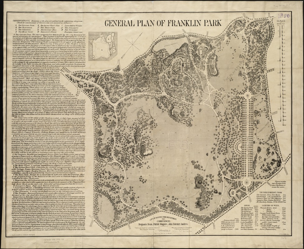
- General plan of Franklin Park
- Description:
-
Boston’s largest park, Franklin Park is considered the “crown jewel” of the Emerald Necklace. To Olmsted, rural scenery offered a physical and visual contrast with the crowding and artificiality of the city, allowing visitors to relax physically and emotionally, consciously and unconsciously. This park plan features dense marginal text in which Olmsted laid out his vision for a country park adorned simply with paths, natural ledges, and native plantings, trimmed not by lawn mowers but by grazing sheep. Franklin Park never fully achieved Olmsted’s original vision, but evolved to feature a woodland preserve and open fields, as well as a zoo, public golf course, pedestrian and bridle paths, a stadium, and other recreational facilities.
- Name on Item:
-
Wm. M. Coombs, del. ; F.L. & J.C. Olmsted, landscape architects.
- Date:
-
1885
- Format:
-
Maps/Atlases
- Location:
-
Boston Public Library
Norman B. Leventhal Map & Education Center - Collection (local):
-
Norman B. Leventhal Map & Education Center Collection
- Subjects:
-
Parks--Massachusetts--Boston--Dorchester--Maps
Franklin Park (Boston, Mass.)--Maps
Dorchester (Boston, Mass.)--Maps
- Places:
-
MassachusettsSuffolk (county)BostonFranklin Park
MassachusettsSuffolk (county)BostonDorchester
- Extent:
- 1 plan ; 69 x 87 cm.
- Terms of Use:
-
No known copyright restrictions.
No known restrictions on use.
- Publisher:
-
Boston, Mass :
[Parks and Recreation Dept.]
- Scale:
-
Scale 1:2,640.
- Language:
-
English
- Notes:
-
Oriented with north toward the upper right.
Includes tables of areas, distances, lenghts and text.
- Notes (exhibitions):
-
Exhibited: "Breathing Room: Mapping Boston's Green Spaces" organized by the Norman B. Leventhal Map Center at the Boston Public Library, 2018.
- Identifier:
-
06_01_003939
- Call #:
-
G3764.B6:2D6 1885 .G4
- Barcode:
-
39999059002699


