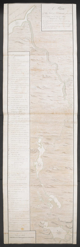
A Plan Of the River of Chibenaccadie from its Source To its Discharge into the Bay of Mines Surveyed in August 1754 : The Length of the River from its Source to its Discharge is 44 Miles. The Distance from the Source of the River to Fort Sacville is 27 Miles. NB the above Distances takes in all the Windings of the Rivers and Lakes
This map is also available in American Revolutionary Geographies Online (ARGO), a collections portal especially built for material relating to the American Revolutionary War Era. Visit ARGO to learn more about this item and explore the historical geography of North America in the late eighteenth century.
Item Information
- Title:
- A Plan Of the River of Chibenaccadie from its Source To its Discharge into the Bay of Mines Surveyed in August 1754 : The Length of the River from its Source to its Discharge is 44 Miles. The Distance from the Source of the River to Fort Sacville is 27 Miles. NB the above Distances takes in all the Windings of the Rivers and Lakes
- Description:
-
A large manuscript map of the River Shubenacadie in Nova Scotia to accompany the manuscript journal of the survey and march.
- Former owner:
- George, III, King of Great Britain, 1738-1820
- Donor:
- George, IV, King of Great Britain, 1762-1830
- Cartographer:
- Tonge, Winckworth, 1727 or 1728-1792
- Date:
-
1754
- Format:
-
Maps/Atlases
Manuscripts
- Location:
- British Library
- Collection (local):
-
British Library Collection
- Subjects:
-
Shubenacadie River (N.S.)--Maps
- Places:
-
CanadaShubenacadie (river)
- Extent:
- 1 map on 3 sheets : joined, manuscript pen and ink with watercolour ; 166 x 45 cm
- Terms of Use:
-
No known copyright restrictions.
This work is licensed for use under a Creative Commons Attribution Non-Commercial Share Alike License (CC BY-NC-SA).

- Scale:
-
Scale 1:47,520
- Language:
-
English
- Catalog Record:
-
http://explore.bl.uk/BLVU1:LSCOP-ALL:BLL01004987891
- Notes:
-
Relief is shown pictorially on the map.
Consider Winckworth Tonge as cartograper is based on the map's stylistic similarities with 'A DRAUGHT of the ISTHMUS which joins Nova Scotia to the Continent ...' which is signed 'W.Tonge' (Maps K.Top.119.64.).
The name Captain Matthew Floyer is not given on the source, nor in the accompanying manuscript journal, but a number of tentative online references to Floyer as this map's cartographer have been located; in Northeast Archaeological Research's Mission Sainte-Anne project http://www.northeastarch.com/sainte_anne.html and in 'My Pioneer Ancestors ...' http://www3.sympatico.ca/jgharris/PioneerAncestors.pdf However, these online references ultimately to refer back to this copy of the map in the King's Topographical Collection.
The scale is given at lower left in its own surround where 5 miles are equal to 6 6/10 inch.
An extensive key is given down the left side of the map identifying places of note and highlighting locations referenced in the accompanying journal of the exploratory march. These include "Fort Sacville", areas of cultivated land, the location of encampments, former French settlements and more.
The map (survey) and journal (see Maps K.Top.119.61.b.) of the march are referenced in 'Journal, October 1754: Volume 61, Part 2', Journals of the Board of Trade and Plantations, Volume 10: January 1754 - December 1758 (1933), pp. 68-76. URL: http://www.british-history.ac.uk/report.aspx?compid=77338 (viewed 2013).
The map is accompanied by a manuscript journal (Maps K.Top.119.61.b.) of the march made by the surveyors, comprising 10 pages of manuscript text.
Titled 'A drawn Plan of the River Chibenaccadie, from its source to its discharge into the Bay of Mines, surveyed in August 1754. Two sheets. With a MS. Journal' in the Catalogue of Maps, Prints, Drawings, etc., forming the geographical and topographical collection attached to the Library of his late Majesty King George the third, etc., London, 1829.
Titled 'A colored "Plan of the River Chibenaccadie, from its source to its discharge into the Bay of Mines [at the head of the Bay of Fundy]; surveyed in August, 1754;" drawn on a scale of 3/4 mile to an inch; 5 f. 6 in. x 1 f. 6 in. Attached is a Ms. journal of the march made by the surveyors' in the Catalogue of the manuscript maps, charts, and plans, and of the topographical drawings in the British Museum.


