Boston open space and supermarkets
Item Information
- Title:
- Boston open space and supermarkets
- Description:
-
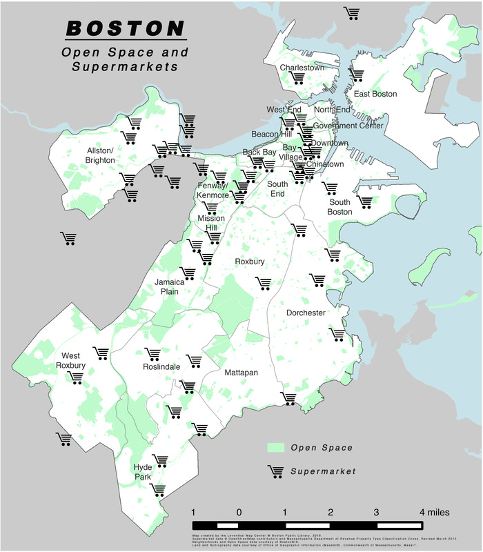
Access to fresh, nutritious food is a major benefit of the gardens, particularly in neighborhoods where supermarkets are low in number. Locations of supermarkets throughout the city are plotted on this maps. Using Geographic Information Systems (GIS), this map allows viewers to visualize geographically referenced data – such as the locations of community gardens or supermarkets. Massachusetts has fewer supermarkets per capita than almost any state in the country (ranking 48th).
- Cartographer:
- Boston Public Library. Norman B. Leventhal Map Center
- Name on Item:
-
map created by the Leventhal Map Center @ Boston Public Library ; supermarket data © OpenStreetMap contributors and Massachusetts Department of Revenue Property Type Classification Zones ; neighborhoods and open space date courtesy of BostonGIS ; land and hydrography data courtesy of Office of Geographic Information (MassGIS), Commonwealth of Massachusetts, MassIT
- Date:
-
2016
- Format:
-
Maps/Atlases
- Location:
-
Boston Public Library
Norman B. Leventhal Map & Education Center - Collection (local):
-
Norman B. Leventhal Map & Education Center Collection
- Subjects:
-
Boston (Mass.)--Maps
Supermarkets--Massachusetts--Boston--Maps
Open spaces--Massachusetts--Boston--Maps
- Places:
-
MassachusettsSuffolk (county)Boston
- Extent:
- 1 map : color
- Terms of Use:
-
No known copyright restrictions.
No known restrictions on use.
- Publisher:
-
[Boston] :
Leventhal Map Center
- Language:
-
English
- Notes (exhibitions):
-
Exhibited: "From the Sea to the Mountains: The Trustees 125th Anniversary" organized by the Norman B. Leventhal Map Center at the Boston Public Library, 2016.
- Identifier:
-
open_space_supermarkets


