Map of the anthracite coalfields of Pennsylvania
Item Information
- Title:
- Map of the anthracite coalfields of Pennsylvania
- Description:
-
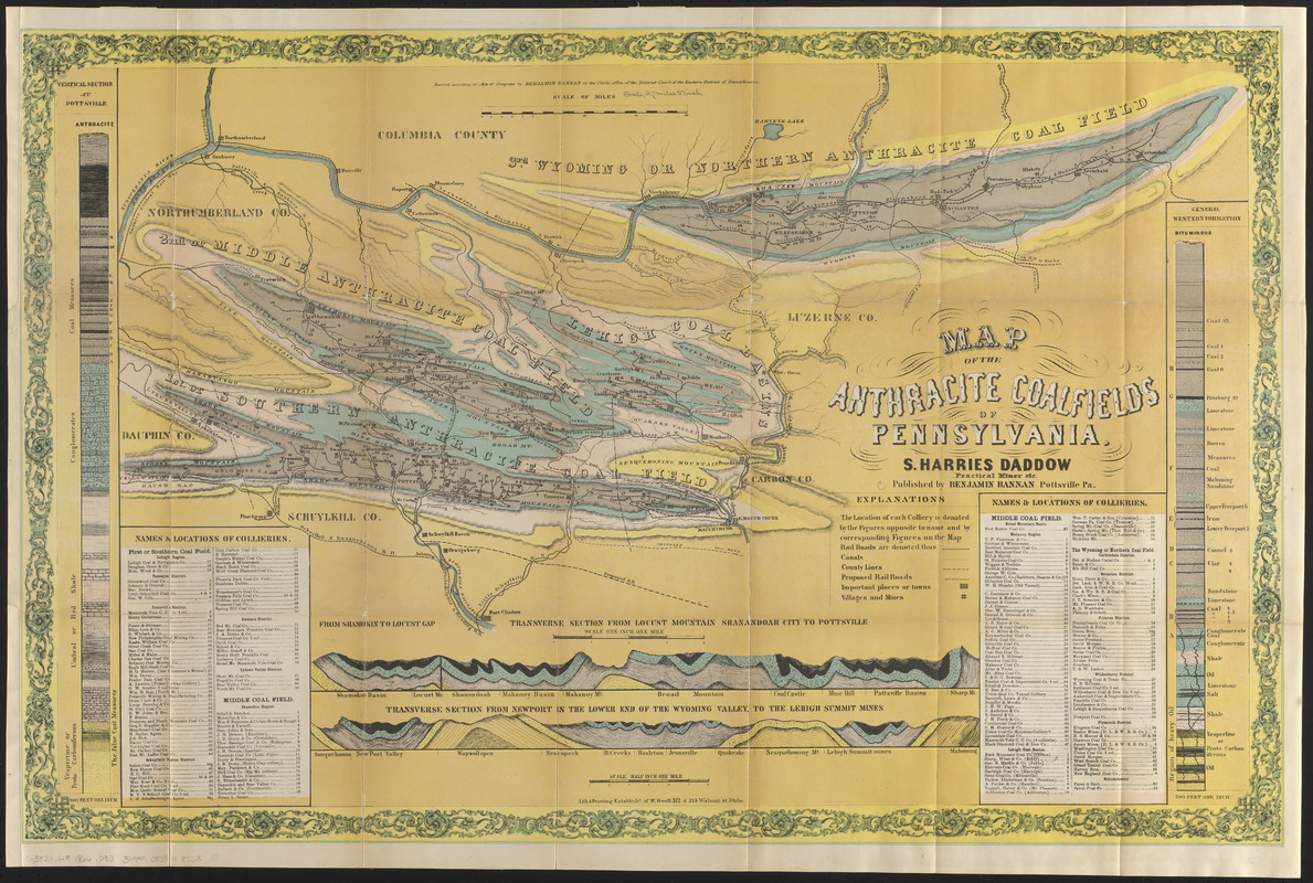
The second half of the 19th century was the peak of anthracite coal mining in Pennsylvania. This 1866 map illustrates the geology of the region, and uses two modern techniques to visualize minerals below ground. A columnar vertical section, seen here along the left edge of the map, represents the makeup of the earth’s crust at a specific place, in this case, Pottsville, Pennsylvania. A transverse view, or, cross section, illustrated along the bottom of the map, shows rock formations between two geographic locations. These visual aids first appeared on maps in the early-19th century, when mapmakers attempted to illustrate Earth’s substructures.
- Cartographer:
- Daddow, Samuel Harries
- Publisher:
- Bannan, Benjamin, 1807-1875
- Printer:
- Boell, William
- Name on Item:
-
S. Harries Daddow
- Date:
-
[1866]
- Format:
-
Maps/Atlases
- Location:
-
Boston Public Library
Norman B. Leventhal Map & Education Center - Collection (local):
-
Norman B. Leventhal Map & Education Center Collection
- Subjects:
-
Anthracite coal--Pennsylvania--Maps
Coal mines and mining--Pennsylvania--Maps
Pennsylvania--Maps
- Places:
-
Pennsylvania
- Extent:
- 1 map : color ; 50 x 81 cm
- Terms of Use:
-
No known copyright restrictions.
No known restrictions on use.
- Publisher:
-
Pottsville, Pa. :
Benjamin Bannan
- Scale:
-
Scale approximately 1:230,000
- Language:
-
English
- Notes:
-
Relief shown by hachures.
Oriented with north to the upper right.
"Entered according to Act of Congress by Benjamin Bannan in the Clerks office of the District Court of the Eastern District of Pennsylvania."
Map removed from: Coal, iron, and oil : or, The practical American miner. A plain and popular work on our mines and mineral resources, and a text-book or guide to their economical development / By Samuel Harries Daddow ... and Benjamin Bannan. Pottsville, Pa. : B. Bannan ; Philadelphia, Pa. ; J.B. Lippincott & Co., 1866. (786, 801-808 pages : illustrations, maps ; 24 cm).
Includes 2 vertical sections, 2 transverse sections, and names and locations of collieries.
- Notes (date):
-
This date is inferred.
- Notes (exhibitions):
-
Exhibited: "Beneath Our Feet: Mapping the World Below" organized by the Norman B. Leventhal Map Center at the Boston Public Library, 2017-2018.
- Identifier:
-
06_01_016397
- Call #:
-
G3821.H9 1866 .D33
- Barcode:
-
39999085948568


