F.T. Neely's new commercial map of the United States, Canada, British Columbia, and Northern Mexico, showing all the railroads, counties, and principal towns up to date : constructed from the latest government and railroad surveys


Item Information
- Title:
- F.T. Neely's new commercial map of the United States, Canada, British Columbia, and Northern Mexico, showing all the railroads, counties, and principal towns up to date : constructed from the latest government and railroad surveys
- Title (alt.):
-
Neely's new reversible historical chart, political map and United states map combined
New commercial map of the United States, Canada, British Columbia, and Northern Mexico
Rand McNally & Co.'s commercial map of the United States and Canada
- Publisher:
- Neely, F. Tennyson (Frank Tennyson), 1863-1941
- Publisher:
- Rand McNally and Company
- Date:
-
1893
- Format:
-
Maps/Atlases
- Location:
-
Boston Public Library
Norman B. Leventhal Map & Education Center - Collection (local):
-
Norman B. Leventhal Map & Education Center Collection
- Subjects:
-
World history
United States--History
United States--Population--Charts, diagrams, etc
United States--Politics and government--Charts, diagrams, etc
United States--Maps
- Places:
-
United States
- Extent:
- 1 map : hand colored ; 96 x 134 cm + advertisement (1 sheet ; 22 x 14 cm)
- Terms of Use:
-
No known copyright restrictions.
No known restrictions on use.
- Publisher:
-
Chicago :
F.T. Neely
- Scale:
-
Scale approximately 1:3,200,000
- Language:
-
English
- Notes:
-
Relief shown by hachures.
Prime meridians: Greenwich and Washington.
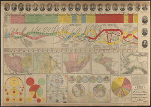
Includes description and statistics of the Columbian Exposition and description and illustration of the Statue of Liberty. Timeline from 1500 to 1890 and 3 charts in margins. Maps, diagrams and illustrations on verso.
Charts: Area and population of foreign countries, compared with the United States, 1890 -- Population of the United States, 1890 -- Population of the United States at intervals of five years, 1780 to 1890.
Timeline: Chronological discoveries, explorations, and important events.
On verso: portraits of 23 U.S. presidents; diagram of the history of political parties in the United States; Persia, Afghanistan and Baluchistan; map of Abyssinia and surrounding countries; Southern Africa comprising Cape of Good Hope, Natal, etc. with Orange River Free State and South African Republic; Central America; Alaska; diagram showing the comparative strength of the armies of the principal countries of the world; the creeds of the world; astronomy; Western Hemisphere; Eastern Hemisphere; diagram showing the tonnage of the navy of various countries and text.
Publisher advertisement allows customers to purchase copies for friends at a discounted price of $1.00. Form for Names of persons who might canvass on verso.
- Identifier:
-
06_01_011989
06_01_011990
- Call #:
-
G3700 1893 .N44
- Barcode:
-
39999065691402


