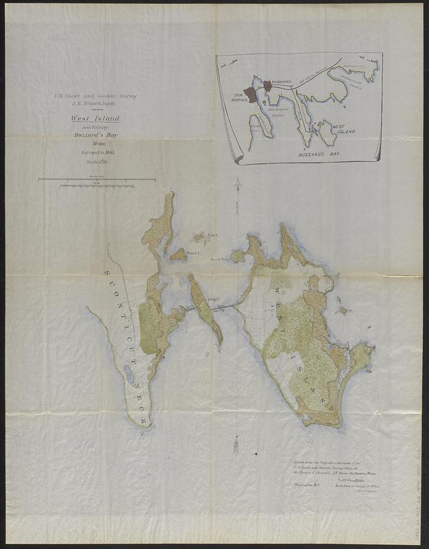
West Island and vicinity, Buzzard's Bay, Mass. : surveyed in 1845 ; copied from the original in archives of the U.S. Coast and Geodetic Survey Office, for Mr. Horace S. Crowell, 27 State St. Boston, Mass.
Item Information
- Title:
- West Island and vicinity, Buzzard's Bay, Mass. : surveyed in 1845 ; copied from the original in archives of the U.S. Coast and Geodetic Survey Office, for Mr. Horace S. Crowell, 27 State St. Boston, Mass.
- Description:
-
Map of West Island and Sconticut Neck on Buzzards Bay, based on an 1845 chart by the U.S. Coast Survey and privately printed around 1885 for real estate magnate Horace S. Crowell, who purchased West Island along with Wing's Neck, Nye's Point, Great Island, and Charles' Neck in 1885.
- Cartographer:
- Boutelle, C. O. (Charles Otis)
- Cartographer:
- U.S. Coast and Geodetic Survey
- Printer:
- Heliotype Printing Co.
- Name on Item:
-
C.O. Boutelle, Assistant, in charge of Office
- Date:
-
[ca. 1885]
- Format:
-
Maps/Atlases
- Location:
-
Boston Public Library
Norman B. Leventhal Map & Education Center - Collection (local):
-
Norman B. Leventhal Map & Education Center Collection
- Subjects:
-
West Island (Mass.)--Maps
Fairhaven (Mass.)--Maps
- Places:
-
MassachusettsBristol (county)West Island (island)
MassachusettsBristol (county)Fairhaven
- Extent:
- 1 map : hand colored ; 71 x 55 cm
- Terms of Use:
-
No known copyright restrictions.
No known restrictions on use.
- Publisher:
-
Boston :
Heliotype Printing Co.
- Scale:
-
Scale approximately 1:10,500
- Language:
-
English
- Notes:
-
Shows buildings, property boundaries, and land cover.
Inset: [Map of the surrounding area].
Scale given on map as 1:10,000, but map is printed at approximately 1:10,500.
Above title: U.S. Coast and Geodetic Survey, J.E. Hilgard, Supt.
- Identifier:
-
06_01_018741
- Call #:
-
G3762.W4 1885 .B68
- Barcode:
-
39999085970182