Relative positions of Rio Grande near El Paso between 1852 and 1907
Item Information
- Title:
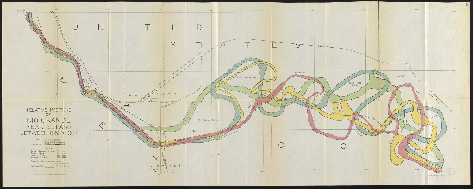
- Relative positions of Rio Grande near El Paso between 1852 and 1907
- Cartographer:
- Follett, W. W.
- Creator:
- International Boundary Commission, United States and Mexico
- Name on Item:
-
compiled from records in my office, W.W. Follett, consulting engineer
- Date:
-
1911
- Format:
-
Maps/Atlases
- Location:
-
Boston Public Library
Norman B. Leventhal Map & Education Center - Collection (local):
-
Norman B. Leventhal Map & Education Center Collection
- Subjects:
-
United States--Boundaries--Mexico--Maps
Mexico--Boundaries--United States--Maps
El Paso (Tex.)--Maps
Ciudad Juárez (Mexico)--Maps
Rio Grande (Colo.-Mexico and Tex.)--Maps
El Chamizal (Mexico and Tex.)--Maps
- Places:
-
MexicoChihuahuaCiudad Juárez
TexasEl Paso (county)El Paso
Grande, Rio (river)
Chamizal
- Extent:
- 1 map : color ; 38 x 96 cm
- Terms of Use:
-
No known copyright restrictions.
No known restrictions on use.
- Publisher:
-
[Washington] :
[Government Printing Office]
- Scale:
-
Scale 1:15,440
- Language:
-
English
- Notes:
-
From Chamizal arbitration / International Boundary Commission, United States and Mexico (Washington : Government Printing Office, 1911).
Shows position of the Rio Grande in 1852, 1889, 1899 and 1907.
Also shows railroads and depots.
”Reproduction verified by the Coast and Geodetic Survey, April 1911.”
- Notes (exhibitions):
-
Exhibited: "Bending lines: maps and data from distortion to deception," organized by the Norman B. Leventhal Map & Education Center at the Boston Public Library, 2020-2021.
- Identifier:
-
06_01_017144
- Call #:
-
4320.45
- Barcode:
-
mq7977369


