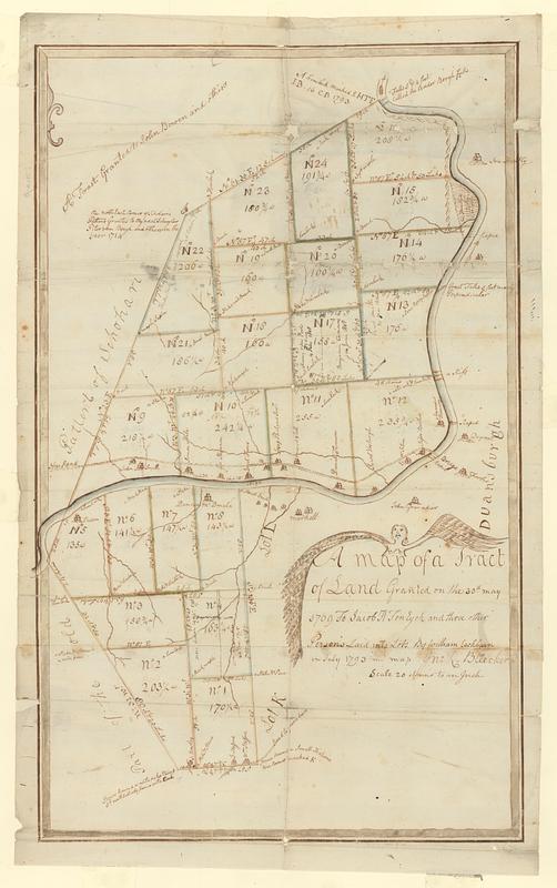
A map of a tract of land granted on the 30th May 1769 to Jacob H. Ten Eyck and three other persons laid into lots
This map is also available in American Revolutionary Geographies Online (ARGO), a collections portal especially built for material relating to the American Revolutionary War Era. Visit ARGO to learn more about this item and explore the historical geography of North America in the late eighteenth century.
Item Information
- Title:
- A map of a tract of land granted on the 30th May 1769 to Jacob H. Ten Eyck and three other persons laid into lots
- Contributor:
- Cockburn, William
- Creator:
- Bleecker, John R., 1713-1800
- Name on Item:
-
by William Cockburn in July 1793 ; my map Jno. R. Bleecker
- Date:
-
1793
- Format:
-
Maps/Atlases
- Genre:
-
Manuscript maps
- Location:
- MacLean Collection Map Library
- Collection (local):
-
MacLean Collection Map Library
- Subjects:
-
Esperance (N.Y.)--Maps--Early works to 1800
Real property--New York (State)--Esperance--Maps--Early works to 1800
Landowners--New York (State)--Esperance--Maps--Early works to 1800
- Places:
-
New YorkSchoharie (county)Esperance
- Extent:
- 1 ms map ; 604 x 375 mm
- Terms of Use:
-
Public Domain/No known restrictions on use. Contact host institution to download image.
Contact host institution for more information.
- Language:
-
English
- Identifier:
-
MC_16552
- Call #:
-
16552