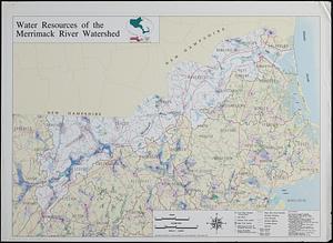
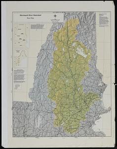
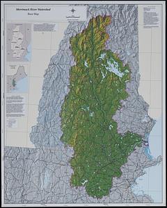
Merrimack River watershed atlas
Item Information
- Title:
- Merrimack River watershed atlas
- Cartographer:
- Applied Geographics, Inc.
- Contributor:
- Merrimack River Initiative
- Name on Item:
-
map design and production by Applied Geographics, Inc.
- Date:
-
1996
- Format:
-
Maps/Atlases
- Genre:
-
Atlases
- Location:
-
Boston Public Library
Norman B. Leventhal Map & Education Center - Collection (local):
-
Applied Geographics, Inc. Records
- Subjects:
-
Merrimack River Watershed (N.H. and Mass.)--Maps
Land cover--Merrimack River Watershed (N.H. and Mass.)--Maps
Water quality--Merrimack River Watershed (N.H. and Mass.)--Maps
Outdoor recreation--Merrimack River Watershed (N.H. and Mass.)--Maps
Protected areas--Merrimack River Watershed (N.H. and Mass.)--Maps
Water use--Merrimack River Watershed (N.H. and Mass.)--Maps
Wellhead protection--Merrimack River Watershed (N.H. and Mass.)--Maps
Fisheries--Merrimack River Watershed (N.H. and Mass.)--Maps
- Places:
-
Merrimack River
- Extent:
- 1 atlas (maps) : color, some plastic ; sheets 59 x 46 cm
- Terms of Use:
-
No known copyright restrictions.
No known restrictions on use.
- Publisher:
-
Boston :
Applied Geographics, Inc.
- Scale:
-
Scales differ
- Language:
-
English
- Table of Contents:
-
Concord Basin
Contoocook Basin
Lower Merrimack Basin
Middle Merrimack Basin
Nashua Basin
Pemigewasset Basin
Upper Merrimack Basin.||Subwatershed base map
Land cover
Water resources and water quality
Recreation and conservation
Water use
Confirmed, threatened and endangered species areas and selected fisheries.
- Notes:
-
Relief shown by shading.
Base map and population map of the entire watershed, and sets of maps for 7 subwatersheds.
Some maps on transparent overlay sheets.
- Identifier:
-
06_01_019032
- Call #:
-
AppGeo Folder 24
- Barcode:
-
30000008058074
![Merrimack River watershed [sheets]](https://bpldcassets.blob.core.windows.net/derivatives/images/commonwealth:kp78ng47v/image_thumbnail_300.jpg)