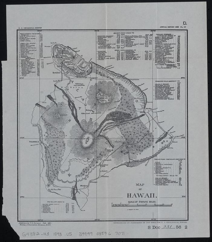
Map of Hawaii
Item Information
- Title:
- Map of Hawaii
- Description:
-
Map of the island of Hawaii showing topography, place names, roads, railroads and traditional political subdivisions (ahupua'a). Lava flows are dated.
- Issuing body:
- Geological Survey (U.S.)
- Cartographer:
- Ourand, Charles H.
- Contributor:
- United States. Congress. Senate. Committee on Foreign Relations
- Contributor:
- United States. Congress (56th, 2nd session : 1900-1901). Senate
- Name on Item:
-
additions by C.H. Ourand, Feb. 1893, Military Information Division, A.G.O.
- Date:
-
[1901]
- Format:
-
Maps/Atlases
- Location:
-
Boston Public Library
Norman B. Leventhal Map & Education Center - Collection (local):
-
Norman B. Leventhal Map & Education Center Collection
- Subjects:
-
Hawaii Island (Hawaii)--Maps
- Places:
-
HawaiiHawaii (county)
- Extent:
- 1 map ; 23 x 20 cm
- Terms of Use:
-
No known copyright restrictions.
No known restrictions on use.
- Publisher:
-
[Washington, D.C.] :
[Government Printing Office]
- Scale:
-
Scale approximately 1:790,000
- Language:
-
English
- Notes:
-
Relief shown by hachures.
Map detached from a United States Senate document (Serial Set 4052 S.doc.231): Compilation of reports of Committee on Foreign Relations, United States Senate, 1789-1901, first Congress, first session, to fifty-sixth Congress, second session. Vol. VI, Diplomatic relations with foreign nations. Hawaiian Islands. Washington : Government Printing Office, 1901.
"January 15, 1901."--Page 2 of accompanying Senate document.
"U.S. Geological Survey"--Upper left margin.
"D."--Upper right margin.
"Annual Report 1883 PL. IV"--Upper right margin.
"S Doc 231 56 2"--Lower right margin.
Includes 9 distance tables.
- Notes (date):
-
This date is inferred.
- Identifier:
-
06_01_018392
- Call #:
-
G4382.H3 1893 .U5
- Barcode:
-
39999085967071


