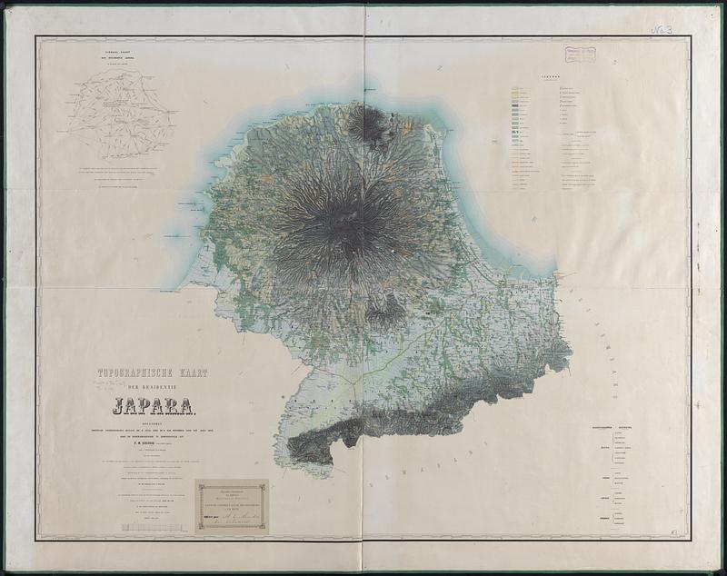
Topographische kaart der residentie Japara : opgenomen ingevolge gouvernements besluit dd. 6 Julij 1866 no. 8 van November 1886 tot Junij 1869 door de Opnemingsbrigade te zamengesteld uit P.M. Ockerse kapitein (chef), den 1e. luitenant F.C.E. Meijer en de opnemers Von Walther [and 15 others]
Item Information
- Title:
- Topographische kaart der residentie Japara : opgenomen ingevolge gouvernements besluit dd. 6 Julij 1866 no. 8 van November 1886 tot Junij 1869 door de Opnemingsbrigade te zamengesteld uit P.M. Ockerse kapitein (chef), den 1e. luitenant F.C.E. Meijer en de opnemers Von Walther [and 15 others]
- Cartographer:
- Netherlands. Topografisch Bureau
- Cartographer:
- Ockerse, P. M.
- Cartographer:
- Bajetto, G. M. F.
- Name on Item:
-
geteekend bij het Topographische Bureau te Batavia door Bajetto [and 4 others]
- Date:
-
[1873]
- Format:
-
Maps/Atlases
- Location:
-
Boston Public Library
Norman B. Leventhal Map & Education Center - Collection (local):
-
Norman B. Leventhal Map & Education Center Collection
- Subjects:
-
Jepara (Indonesia)--Maps
Jepara (Dutch East Indies : Residency)--Maps
- Places:
-
IndonesiaCentral Java (province)Jepara
- Extent:
- 1 map : color ; 92 x 120 cm
- Terms of Use:
-
No known copyright restrictions.
No known restrictions on use.
- Publisher:
-
s Gravenhage :
Topographische inrigting
- Scale:
-
Scale 1:100,000
- Language:
-
Dutch
- Notes:
-
Relief shown by hachures and spot heights.
Prime meridian: Batavia [that is, Jakarta].
"De beschrijving is overgenomen volgens de statiscke opgave van de jaren 1871-1873."
Includes Signaal kaart der residentie Japara.
Label from Exposition internationale des industries maritimes et fluviales pasted in lower left.
- Notes (date):
-
This date is inferred.
- Identifier:
-
06_01_015317
- Call #:
-
G8074.J55 1873 .N48
- Barcode:
-
39999085934477


