Map of Pond Town Plantation, Maine
Item Information
- Title:
- Map of Pond Town Plantation, Maine
- Creator:
- Whittier, Charles Collyer
- Editor:
- Whittier, Charles Collyer
- Editor:
- Benjamin, John M.
- Engraver:
- Alexander, W.
- Name on Item:
-
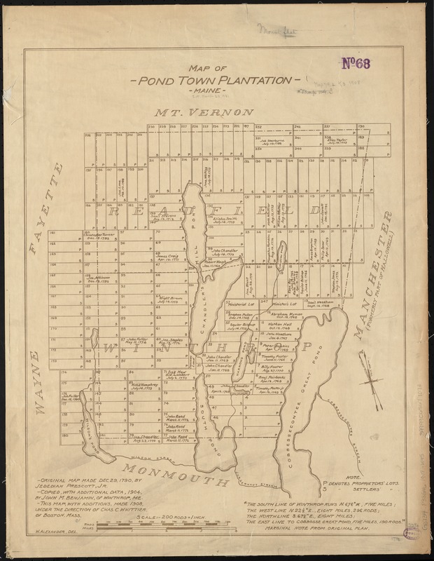
original map made Dec. 29, 1790, by Jedediah Prescott, Jr. ; copied, with additional data, 1904, by John M. Benjamin, of Winthrop, ME ; this map, with additions, made 1908, under the direction of Chas. C. Whittier, of Boston, Mass. ; W. Alexander del.
- Date:
-
1908
- Format:
-
Maps/Atlases
- Location:
-
Boston Public Library
Norman B. Leventhal Map & Education Center - Collection (local):
-
Norman B. Leventhal Map & Education Center Collection
- Subjects:
-
Real property--Maine--Pond Town--Maps
Landowners--Maine--Pond Town--Maps
Pond Town (Me.)--Maps
Winthrop (Me. : Town)--Maps
- Places:
-
MaineKennebec (county)Winthrop
- Extent:
- 1 map ; 57 x 44 cm.
- Terms of Use:
-
No known copyright restrictions.
No known restrictions on use.
- Publisher:
-
Boston :
[s.n.]
- Scale:
-
Scale [1:39,600]
- Language:
-
English
- Notes:
-
Shows lots and some landowners.
Oriented with north towards the upper left.
- Identifier:
-
06_01_010417
- Call #:
-
G3734.P38G46 1908 .W45
- Barcode:
-
39999065671073


