Map of Cattaraugus Co., New York : from the county records & actual surveys
Item Information
- Title:
- Map of Cattaraugus Co., New York : from the county records & actual surveys
- Cartographer:
- Geil, Samuel
- Cartographer:
- Godshalk, S. K.
- Publisher:
- Tiffany, J. M. (Publisher)
- Copyright holder:
- Smith, Robert Pearsall, 1827-1898
- Name on Item:
-
by Samuel Geil, author of maps of Orleans, Cayuga, Erie etc. ; surveys by S.K. Godshalk
- Date:
-
1856
- Format:
-
Maps/Atlases
- Location:
-
Boston Public Library
Norman B. Leventhal Map & Education Center - Collection (local):
-
Norman B. Leventhal Map & Education Center Collection
- Subjects:
-
Landowners--New York (State)--Cattaraugus County--Maps
Real property--New York (State)--Cattaraugus County--Maps
Cities and towns--New York (State)--Cattaraugus County--Maps
Villages--New York (State)--Cattaraugus County--Maps
Cattaraugus County (N.Y.)--Maps
Olean (N.Y.)--Maps
- Places:
-
New YorkCattaraugus (county)Olean
- Extent:
- 1 map : color ; 140 x 148 cm
- Terms of Use:
-
No known copyright restrictions.
No known restrictions on use.
- Publisher:
-
Fredonia, Chautauque Co., N.Y. :
Publisher J.M. Tiffany
- Scale:
-
Scale approximately 1:50,688
- Language:
-
English
- Notes:
-
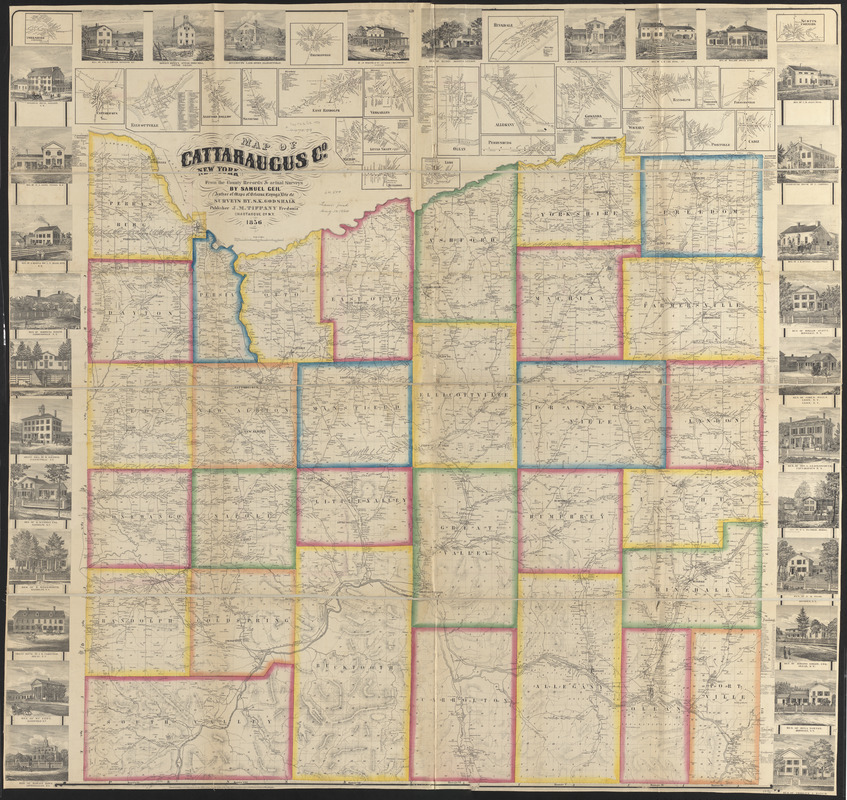
General-content county map showing towns (townships), numbered town sections, some rural land tracts with owner's names, rural buildings, and householder's names.
Relief shown by hachures.
Colored to emphasize town boundaries and areas.
"Entered according to Act of Congress in the year 1856 by Robert Pearsall Smith in the ... Eastern District of Pennsylvania."
Includes 24 village insets (including Olean), local business directories, and illustrations of prominent buildings/residences.
- Notes (citation):
-
LC Land ownership maps, 477
- Identifier:
-
06_01_010623
- Call #:
-
G3803.C2 1856 .G45
- Barcode:
-
39999065675215


