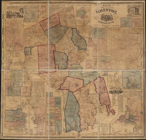
Atlas of Bristol Co., Massachusetts : from actual surveys

Item Information
- Title:
- Atlas of Bristol Co., Massachusetts : from actual surveys
- Title (alt.):
-
Atlas of Bristol County, Massachusetts
- Cartographer:
- Beers, F. W. (Frederick W.)
- Cartographer:
- Sanford, G. P. (George P.)
- Cartographer:
- Neumann, Louis E.
- Publisher:
- F.W. Beers & Co.
- Name on Item:
-
by and under the direction of F.W. Beers ; assisted by Geo. P. Sanford and others ; Chas. Hart, lithographer
- Date:
-
1871
- Format:
-
Maps/Atlases
Books
- Location:
-
Boston Public Library
Norman B. Leventhal Map & Education Center - Collection (local):
-
Norman B. Leventhal Map & Education Center Collection
- Subjects:
-
Bristol County (Mass.)--Maps
Real property--Massachusetts--Bristol County--Maps
Landowners--Massachusetts--Bristol County--Maps
- Places:
-
MassachusettsBristol (county)
- Extent:
- 1 atlas (5 pages, 50 leaves of plates) : color maps (some folded) ; 41 cm
- Terms of Use:
-
No known copyright restrictions.
No known restrictions on use.
- Publisher:
-
New York :
F.W. Beers & Co.
- Language:
-
English
- Notes:
-
Relief shown by hachures.
Shows names of property owners.
"Louis E. Neuman, engraver."
"History of Bristol County": page 5.
Includes "Plan of Massachusetts, Rhode Island and Connecticut" and index.
Includes table of distances, history, state map, county map and business directories for several cities.
- Identifier:
-
06_01_018467
- Call #:
-
G1233.B7 B44 1871
- Barcode:
-
39999059010247