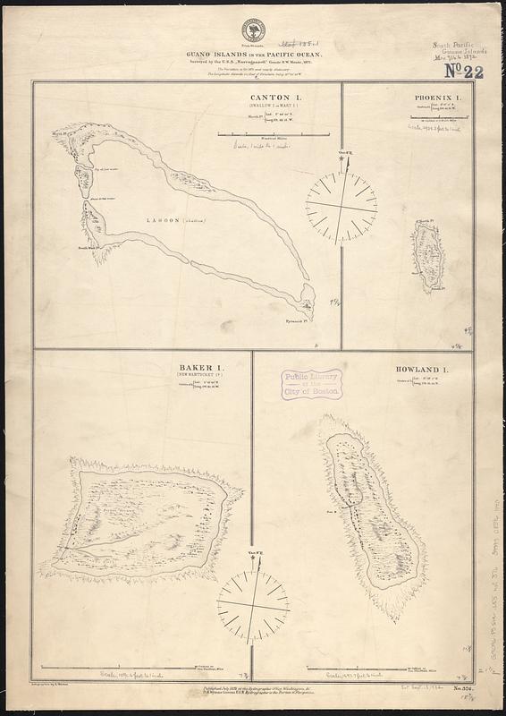
Guano islands in the Pacific Ocean
Item Information
- Title:
- Guano islands in the Pacific Ocean
- Issuing body:
- United States. Hydrographic Office
- Contributor:
- Welcker, A.
- Surveyor:
- Narragansett (Sloop)
- Name on Item:
-
surveyed by the U.S.S. "Narragansett" Comdr. R.W. Meade, 1872 ; autographed by A. Welcker
- Date:
-
1872
- Format:
-
Maps/Atlases
- Genre:
-
Nautical charts
- Location:
-
Boston Public Library
Norman B. Leventhal Map & Education Center - Collection (local):
-
Norman B. Leventhal Map & Education Center Collection
- Subjects:
-
Kanton (Kiribati)--Maps
Rawaki Island (Kiribati)--Maps
Baker Island--Maps
Howland Island--Maps
Nautical charts--Kiribati--Kanton
Nautical charts--Kiribati--Rawaki Island
Nautical charts--Baker Island
Nautical charts--Howland Island
- Places:
-
KiribatiKanton (island)
KiribatiRawaki (atoll)
Baker Island (possession)
Howland Island (possession)
- Extent:
- 4 maps on 1 sheet ; 55 x 41 cm
- Terms of Use:
-
No known copyright restrictions.
No known restrictions on use.
- Publisher:
-
Washington, D.C. :
Hydrographic Office
- Scale:
-
Scale approximately 1:13,000
Scale approximately 1:20,400
Scale approximately 1:35,700
Scale approximately 1:72,300
- Language:
-
English
- Table of Contents:
-
Canton I. (Swallow I. or Mary I.)
Phoenix I.
Baker I. (New Nantucket I.)
Howland I.
- Notes:
-
Relief shown pictorially. Depths shown pictorially.
- Identifier:
-
06_01_017567
- Call #:
-
G9096.P5 svar .U55 no. 376
- Barcode:
-
39999085961140


