Selected land use in oblique perspective
Item Information
- Title:
- Selected land use in oblique perspective
- Cartographer:
- MassGIS (Office : Mass.)
- Date:
-
[ca. 1986]
- Format:
-
Maps/Atlases
- Genre:
-
Aerial views
Topographic maps
- Location:
-
Boston Public Library
Norman B. Leventhal Map & Education Center - Collection (local):
-
Applied Geographics, Inc. Records
- Subjects:
-
Wellfleet (Mass. : Town)--Maps
Wellfleet (Mass. : Town)--Aerial views
Truro (Mass. : Town)--Maps
Truro (Mass. : Town)--Aerial views
Land use--Massachusetts--Wellfleet (Town)--Maps
Land use--Massachusetts--Truro (Town)--Maps
- Places:
-
MassachusettsBarnstable (county)Wellfleet
MassachusettsBarnstable (county)Truro
- Extent:
- 1 map : color ; 26 x 41 cm
- Terms of Use:
-
No known copyright restrictions.
No known restrictions on use.
- Publisher:
-
[Massachusetts] :
[MassGIS]
- Scale:
-
Not drawn to scale
- Language:
-
English
- Notes:
-
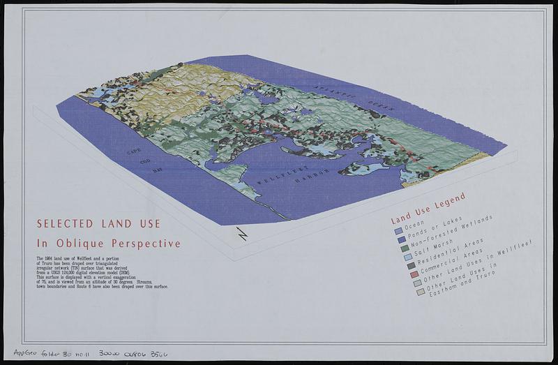
Relief shown by land forms.
Shows 1984 land use, streams, town boundaries, and route 6 for Wellfleet and part of Truro.
- Identifier:
-
06_01_019048
- Call #:
-
AppGeo Folder 30 no. 11
- Barcode:
-
30000008063566


