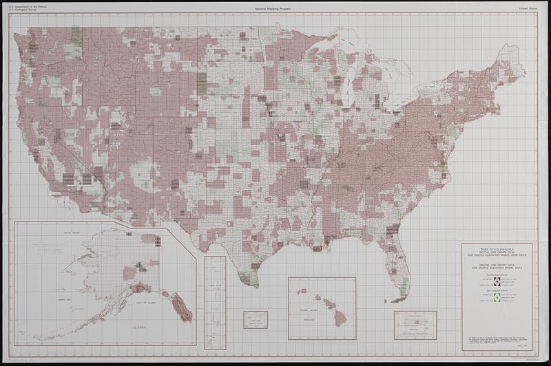
Index to 1:24,000-scale digital line graph (DLG) and digital elevation model (DEM) data
Item Information
- Title:
- Index to 1:24,000-scale digital line graph (DLG) and digital elevation model (DEM) data
- Title (alt.):
-
Index to 1:24,000-scale digital line graph (DLG) and digital elevation data, United States
Digital line graph data and digital elevation model data [index map], United States
- Issuing body:
- Geological Survey (U.S.). National Mapping Division
- Name on Item:
-
U.S. Department of the Interior, U.S. Geological Survey, National Mapping Program
- Date:
-
1995
- Format:
-
Maps/Atlases
- Genre:
-
Index maps
- Location:
-
Boston Public Library
Norman B. Leventhal Map & Education Center - Collection (local):
-
Applied Geographics, Inc. Records
- Subjects:
-
United States--Maps--Indexes
Altitudes--Databases--Maps
- Places:
-
United States
- Extent:
- 2 maps : color, both sides ; 77 x 119 cm
- Terms of Use:
-
No known copyright restrictions.
No known restrictions on use.
- Publisher:
-
Reston, Virginia :
Interior-Geological Survey
- Scale:
-
Scale approximately 1:4,400,000
- Language:
-
English
- Table of Contents:
-
Digital line graph data and digital elevation model data
Digital line graph data.
- Notes:
-
Shows completed and in process DLG and DEM data for United States 7.5 minute quadrangles.
"April 1, 1995."
"38077-H1-IG-99X-06."
Inset maps -- Puerto Rico and Virgin Islands, Hawaii, American Samoa, Mariana Islands, Alaska.
- Identifier:
-
06_01_019103
- Call #:
-
AppGeo Folder 34 no.7


