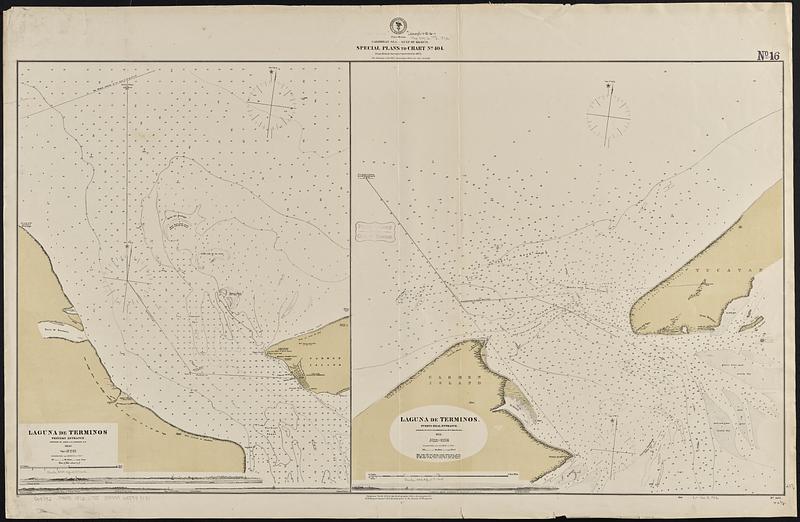
Caribbean Sea--Gulf of Mexico, special plans to chart no. 404 : from British surveys, corrected to 1872
Item Information
- Title:
- Caribbean Sea--Gulf of Mexico, special plans to chart no. 404 : from British surveys, corrected to 1872
- Issuing body:
- United States. Hydrographic Office
- Surveyor:
- Lawrance, G. B. (George Bennett), 1815-1853
- Date:
-
1872
- Format:
-
Maps/Atlases
- Genre:
-
Nautical charts
- Location:
-
Boston Public Library
Norman B. Leventhal Map & Education Center - Collection (local):
-
Norman B. Leventhal Map & Education Center Collection
- Subjects:
-
Terminos Lagoon (Mexico)--Maps
Nautical charts--Mexico--Terminos Lagoon
- Places:
-
MexicoCampecheTérminos, Laguna de (lagoon)
- Extent:
- 2 maps on 1 sheet ; 61 x 108 cm
- Terms of Use:
-
No known copyright restrictions.
No known restrictions on use.
- Publisher:
-
Washington, D.C. :
Hydrographic Office
- Scale:
-
Scale approximately 1:19,000
Scale approximately 1:27,000
- Language:
-
English
- Table of Contents:
-
Laguna de Terminos: western entrance
Laguna de Terminos: Puerto Real entrance
- Notes:
-
Depths shown by soundings and isolines.
Includes 3 coastal views.
- Identifier:
-
06_01_015721
- Call #:
-
G9096.P5 svar .U55 no. 405
- Barcode:
-
39999085940151


