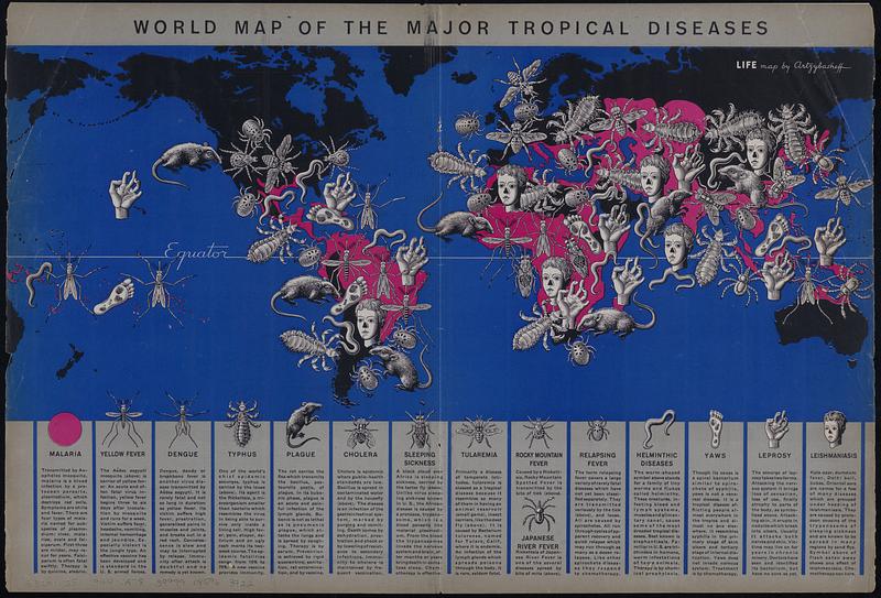
World map of the major tropical diseases

Item Information
- Title:
- World map of the major tropical diseases
- Artist:
- Artzybasheff, Boris, 1899-1965
- Name on Item:
-
by Artzybasheff
- Date:
-
[1944]
- Format:
-
Maps/Atlases
- Genre:
-
World maps
Pictorial maps
- Location:
-
Boston Public Library
Norman B. Leventhal Map & Education Center - Collection (local):
-
Norman B. Leventhal Map & Education Center Collection
- Subjects:
-
Diseases--Maps
Tropical medicine--Maps
- Places:
-
World
- Extent:
- 1 map : color ; 23 x 52 cm, on sheet 36 x 52 cm
- Terms of Use:
-
No known copyright restrictions.
No known restrictions on use.
- Publisher:
-
[Chicago, Illinois] :
Life
- Scale:
-
Scale not given
- Language:
-
English
- Notes:
-
Pictorial map.
Shows locations of diseases around the world using text, illustrations and color. Includes description of each disease at foot of map.
From Life magazine, May 1, 1944.
Includes brief descriptions of 15 diseases, including malaria, yellow fever, dengue, typhus, plague, cholera, sleeping sickness, tularemia, Rocky Mountain fever, Japanese river fever, relapsing fever, helminthic diseases, yaws, leprosy, and leishmaniasis.
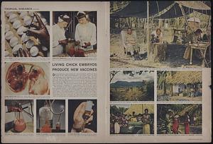
Text and color illustrations on verso. Verso running head: "Tropical diseases." Caption: "Living chick embryos produce new vaccines."
- Notes (date):
-
This date is inferred.
- Identifier:
-
06_01_017930_A
06_01_017930_B
- Call #:
-
G3201.E51 1944 .A78
- Barcode:
-
39999085963922


