Cobb's latest map of the Rosebud Reservation, South Dakota, to be opened for settlement Aug. 8, 1904
Item Information
- Title:
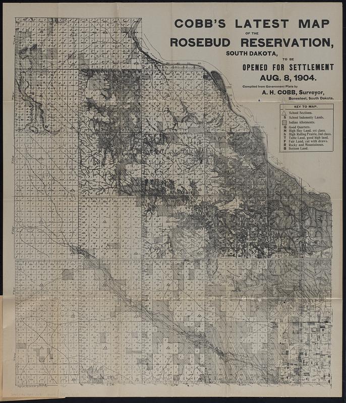
- Cobb's latest map of the Rosebud Reservation, South Dakota, to be opened for settlement Aug. 8, 1904
- Title (alt.):
-
Newest and latest quarter-sectional map of the Rosebud Reservation, Gregory County, South Dakota : with President's proclamation, how to read corner stones, and other information
- Cartographer:
- Cobb, A. H.
- Printer:
- Burd & Fletcher Printing Company
- Name on Item:
-
compiled from government plats by A.H. Cobb, surveyor, Bonestreet, South Dakota
- Date:
-
[1904?]
- Format:
-
Maps/Atlases
- Location:
-
Boston Public Library
Norman B. Leventhal Map & Education Center - Collection (local):
-
Norman B. Leventhal Map & Education Center Collection
- Subjects:
-
Rosebud Indian Reservation (S.D.)--Maps
Gregory County (S.D.)--Maps
Land tenure--South Dakota--Gregory County
Indian land transfers--South Dakota
Dakota Indians--Land tenure
- Places:
-
South DakotaRosebud Indian Reservation
South DakotaGregory (county)
- Extent:
- 1 map ; sheet 71 x 61 cm, folded in cover 19 x 13 cm + text (8 pages ; 19 cm)
- Terms of Use:
-
No known copyright restrictions.
No known restrictions on use.
- Publisher:
-
Kansas City [Missouri] :
Burd & Fletcher Print. Co.
- Scale:
-
Scale approximately 1:167,500
- Language:
-
English
- Notes:
-
Relief shown by hachures.
Accompanying text (8 pages ; 19 cm) includes preface, presidential proclamation opening the reservation, circular listing qualifications to homestead entry, and text about section corners.
"Copy [illegible] by A.H. Cobb June 20, 1904."
- Notes (exhibitions):
-
Exhibited: "More or less in common: environment and justice in the human landscape," organized by Leventhal Map & Education Center at the Boston Public Library, 2022.
- Identifier:
-
06_01_018283
- Call #:
-
G4182.R6 1904 .C63
- Barcode:
-
39999085965133


