South Pacific Ocean, Solomon Islands, Guadalcanal and Florida Is. with a portion of Malaita I. : from British surveys to 1912
Item Information
- Title:
- South Pacific Ocean, Solomon Islands, Guadalcanal and Florida Is. with a portion of Malaita I. : from British surveys to 1912
- Publisher:
- United States. Hydrographic Office
- Name on Item:
-
Hydrographic Office, U.S. Navy
- Date:
-
1942
- Format:
-
Maps/Atlases
- Genre:
-
Nautical charts
- Location:
-
Boston Public Library
Norman B. Leventhal Map & Education Center - Collection (local):
-
Norman B. Leventhal Map & Education Center Collection
- Subjects:
-
Florida Islands (Solomon Islands)--Maps
Guadalcanal (Solomon Islands)--Maps
Malaita Province (Solomon Islands)--Maps
Navigation--Solomon Islands--Florida Islands
Navigation--Solomon Islands--Guadalcanal
Navigation--Solomon Islands--Malaita Province
Tassafaronga, Battle of, Solomon Islands, 1942--Maps
- Places:
-
Solomon IslandsCentral (province)Florida Islands (area)
Solomon IslandsGuadalcanal (province)
Solomon IslandsMalaita (province)
- Extent:
- 1 map ; 65 x 95 cm
- Terms of Use:
-
No known copyright restrictions.
No known restrictions on use.
- Publisher:
-
Washington, D.C. :
Hydrographic Office
- Edition:
- 4th ed., Apr. 1941
- Scale:
-
Scale 1:217,296 at lat. 9°20ʹ
- Language:
-
English
- Notes:
-
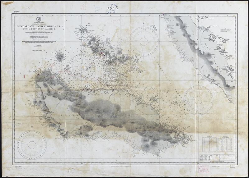
Relief shown by contours and spot heights. Depths shown by soundings.
Includes manuscript annotations in pencil and ink drawn by a radar officer on the USS Minneapolis during the battle of Tassafaronga.
Includes notes, corrections log, conversion table, and tidal information.
"No. 2916."
Stamped: Corrected through notice to mariners no 32 Aug 12 '42.
- Notes (acquisition):
-
Gift of David Loutzenheiser in memory of Edward C. Callahan, January 2022.
- Identifier:
-
06_01_018292
- Call #:
-
G9282.G8P5 1942 .U5
- Barcode:
-
39999085965265


