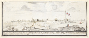
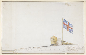
[Fort William and Mary on Piscataqua River]
![[Fort William and Mary on Piscataqua River]](https://bpldcassets.blob.core.windows.net/derivatives/images/commonwealth:6108vv71t/image_access_800.jpg)
This map is also available in American Revolutionary Geographies Online (ARGO), a collections portal especially built for material relating to the American Revolutionary War Era. Visit ARGO to learn more about this item and explore the historical geography of North America in the late eighteenth century.
Item Information
- Title:
- [Fort William and Mary on Piscataqua River]
- Description:
-
Plan of Fort William and Mary on the Island of New Castle surrounded by Piscataqua River, with a view in profile of the Fort as it formerly was showing a cannon and a piece of wall above, and two sections of the bastions and a detail of the watch-house below; scale and explanatory text, within washline.||Titled ‘A drawn Plan of Her Majesty's Fort William and Mary, on Piscataqua River, America, 1705; with a Profile of ditto’ in the Catalogue of the Maps, Prints, Drawings, etc., forming the geographical and topographical collection attached to the Library of his late Majesty King George the third, etc., London, 1829.||Titled 'A colored plan of "Her Majesty's Fort William and Mary, on Piscataqua River, America, 1705;" drawn on a scale of 55 feet to an inch; with profils on a scale of 13 feet to an inch' in the Catalogue of the manuscript maps, charts, and plans, and of the topographical drawings in the British Museum, London, 1844-1861.
- Artist:
- Romer, Wolfgang William, 1640-1713
- Former owner:
- George, III, King of Great Britain, 1738-1820
- Donor:
- George, IV, King of Great Britain, 1762-1830
- Date:
-
1705
- Format:
-
Drawings/Illustrations
Manuscripts
- Genre:
-
Views
- Location:
- British Library
- Collection (local):
-
British Library Collection
- Subjects:
-
Fortification--New Hampshire--Fort Constitution--Pictorial works--Early works to 1800
Fort Constitution (N.H.)--Pictorial works--Early works to 1800
- Places:
-
Fort Constitution (historical)
- Extent:
- 1 drawing : ink and wash ; sheet 43.8 x 58.5 cm
- Terms of Use:
-
No known copyright restrictions.
This work is licensed for use under a Creative Commons Attribution Non-Commercial Share Alike License (CC BY-NC-SA).

- Scale:
-
Scale 1:660
- Language:
-
English
- Catalog Record:
-
http://explore.bl.uk/BLVU1:LSCOP-ALL:BLL01004987812
- Notes:
-
Production details from other drawings by the same hand in the same volume (see Maps K.Top.120.39.a. and Maps K.Top.120.39.b.).
Title and date written in brown ink on verso.