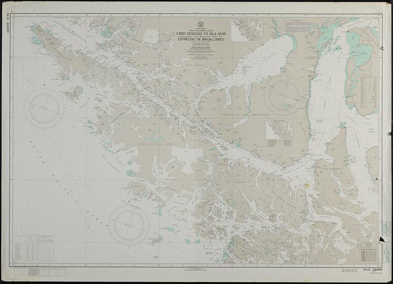
South America, Chile--southwest coast, Cabo Deseado to Isla Noir including the western part of Estrecho de Magallanes (Strait of Magellan) : from Chilean charts to 1958 with additions from other sources to 1965
Item Information
- Title:
- South America, Chile--southwest coast, Cabo Deseado to Isla Noir including the western part of Estrecho de Magallanes (Strait of Magellan) : from Chilean charts to 1958 with additions from other sources to 1965
- Cartographer:
- United States. Naval Oceanographic Office
- Name on Item:
-
prepared and published by the Defense Mapping Agency Hydrographic Center
- Date:
-
1976
- Format:
-
Maps/Atlases
- Genre:
-
Nautical charts
- Location:
-
Boston Public Library
Norman B. Leventhal Map & Education Center - Collection (local):
-
Applied Geographics, Inc. Records
- Subjects:
-
Pacific Coast (Chile)--Navigation
South Pacific Ocean--Navigation
Magellan, Strait of (Chile and Argentina)--Navigation
- Places:
-
ChileMagallanes y de la Antártica Chilena (region)Magellan, Strait of
- Extent:
- 1 map : color ; 81 x 120 cm
- Terms of Use:
-
No known copyright restrictions.
No known restrictions on use.
- Publisher:
-
Washington, D.C. :
U.S. Naval Oceanographic Office
- Edition:
- 27th ed., Mar. 4, 1968; revised 3/12/73.
- Scale:
-
Scale 1:276,600 at lat. 53°40'
- Projection:
- Mercator projection
- Language:
-
English
- Notes:
-
"Soundings in fathoms and feet."
Depths shown by isolines and soundings.
"Heights in meters above mean sea level."
Relief shown by hachures and spot heights.
"N.O. 22410."
Includes compilation diagram, index to overlapping and next larger scale charts, tidal information, glossary, and conversion table.
Stamped: Corrected through notice to mariners no. 26 June 28, 1875.
Stamped: Revised by Defense Mapping Agency Depot Clearfield Utah 6/30/75.
- Identifier:
-
06_01_019091
- Call #:
-
AppGeo Folder 33 no.4


