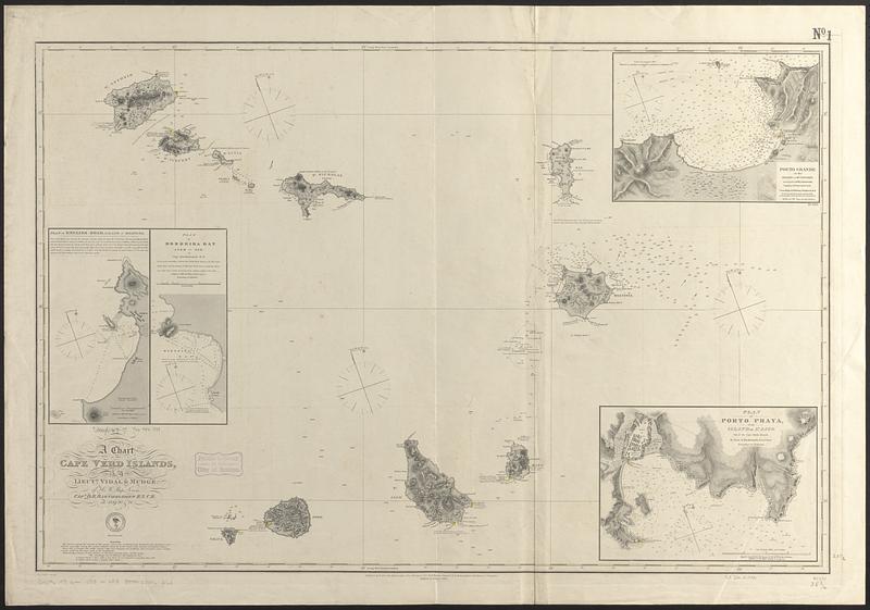
A chart of the Cape Verd Islands
Item Information
- Title:
- A chart of the Cape Verd Islands
- Issuing body:
- United States. Hydrographic Office
- Surveyor:
- Bartholomew, David Ewen, approximately 1767-1821
- Surveyor:
- Dickinson, S.
- Surveyor:
- Mudge, William, 1796-1837
- Surveyor:
- Nares, George S. (George Strong), 1831-1915
- Surveyor:
- Vidal, A. T. E. (Alexander Thomas Emeric), 1792-1863
- Name on Item:
-
by Lieuts. Vidal & Mudge, of H.M. Ship Leven, Capt. D.E. Bartholomew R.N. C.B. in 1819, 20 & 21
- Date:
-
1888
- Format:
-
Maps/Atlases
- Genre:
-
Nautical charts
- Location:
-
Boston Public Library
Norman B. Leventhal Map & Education Center - Collection (local):
-
Norman B. Leventhal Map & Education Center Collection
- Subjects:
-
Cabo Verde--Maps
Nautical charts--Cabo Verde
- Places:
-
Cape Verde
- Extent:
- 1 map ; 60 x 92 cm
- Terms of Use:
-
No known copyright restrictions.
No known restrictions on use.
- Publisher:
-
Washington, D.C. :
Hydrographic Office
- Edition:
- Edition of October 1888
- Scale:
-
Scale approximately 1:490,000
- Language:
-
English
- Notes:
-
Relief shown by hachures and spot heights. Depths shown by soundings.
Insets: Plan of English Road, island of Boavista -- Plan of Mordeira Bay, isle of Sal -- Porto Grande in the island of St. Vincent -- Plan of Porto Praya in the island of St. Jago.
"Cor. 1888-44.47."
- Identifier:
-
06_01_017704
- Call #:
-
G9096.P5 svar .U55 no. 253
- Barcode:
-
39999085962163


