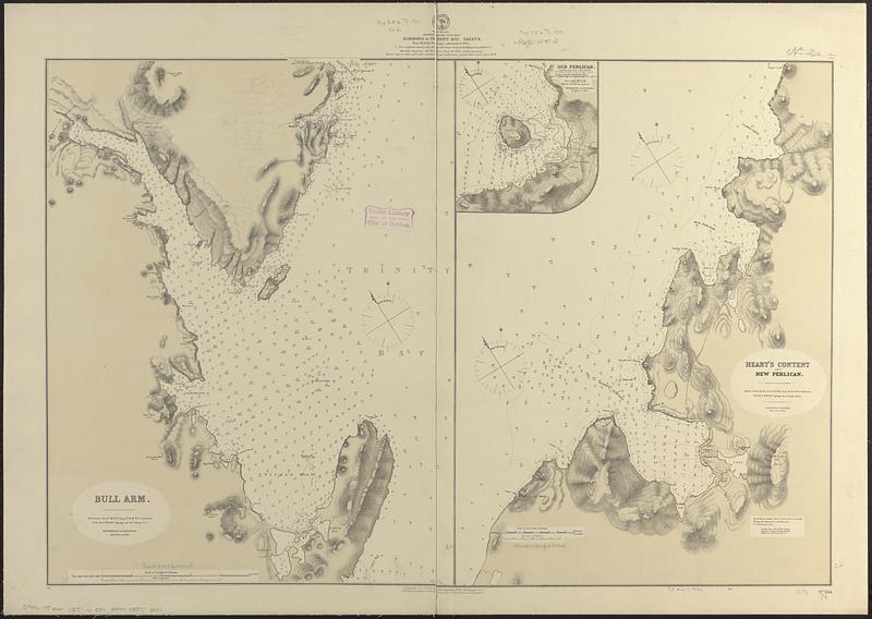
Newfoundland, east coast, harbors in Trinity Bay, sheet II : from British surveys, corrected to 1874
Item Information
- Title:
- Newfoundland, east coast, harbors in Trinity Bay, sheet II : from British surveys, corrected to 1874
- Title (alt.):
-
Bull Arm
Heart's Content and New Perlican
- Issuing body:
- United States. Hydrographic Office
- Date:
-
1874
- Format:
-
Maps/Atlases
- Genre:
-
Nautical charts
- Location:
-
Boston Public Library
Norman B. Leventhal Map & Education Center - Collection (local):
-
Norman B. Leventhal Map & Education Center Collection
- Subjects:
-
Trinity Bay (N.L.)--Maps
Bull Arm (N.L.)--Maps
Tickle Bay (N.L.)--Maps
Heart's Content (N.L. : Harbor)--Maps
New Perlican Harbour (N.L.)--Maps
Nautical charts--Newfoundland and Labrador--Trinity Bay
Nautical charts--Newfoundland and Labrador--Bull Arm
Nautical charts--Newfoundland and Labrador--Tickle Bay
Nautical charts--Newfoundland and Labrador--Heart's Content (Harbor)
Nautical charts--Newfoundland and Labrador--New Perlican Harbour
- Places:
-
CanadaNewfoundland and Labrador (province)Trinity Bay
Bull Arm
Tickle Bay
Heart's Content
New Perlican Harbour
- Extent:
- 2 maps on 1 sheet ; 62 x 92 cm
- Terms of Use:
-
No known copyright restrictions.
No known restrictions on use.
- Publisher:
-
Washington, D.C. :
Hydrographic Office
- Scale:
-
Scale approximately 1:19,000
Scale approximately 1:54,000
- Language:
-
English
- Table of Contents:
-
Bull Arm
Heart's Content and New Perlican
- Notes:
-
Relief shown by hachures and spot heights. Depths shown by soundings and isolines.
Inset: Old Perlican.
- Identifier:
-
06_01_017045
- Call #:
-
G9096.P5 svar .U55 no. 584
- Barcode:
-
39999085953881