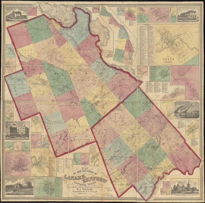
Map of the counties of Lanark and Renfrew, Canada West : from actual surveys under the direction of H.F. Walling
Item Information
- Title:
- Map of the counties of Lanark and Renfrew, Canada West : from actual surveys under the direction of H.F. Walling
- Creator:
- Gray, Ormando Willis.
- Name on Item:
-
surveyed and drawn by O.W. Gray, civil engineer ; assisted by Albert Davis, S.S. Southworth.
- Date:
-
1863
- Format:
-
Maps/Atlases
- Location:
-
Boston Public Library
Norman B. Leventhal Map & Education Center - Collection (local):
-
Norman B. Leventhal Map & Education Center Collection
- Subjects:
-
Landowners--Ontario--Lanark (County)--Maps
Landowners--Ontario--Renfrew (County)--Maps
Lanark (Ont. : County)--Maps
Renfrew (Ont. : County)--Maps
- Places:
-
Lanark County
Renfrew County
- Extent:
- 1 map : map colored ; 143 x 142 cm.
- Terms of Use:
-
No known copyright restrictions.
No known restrictions on use.
- Publisher:
-
Prescott, C.W. :
D.P. Putnam,
- Scale:
-
Scale approximately 1:96,500
- Language:
-
English
- Notes:
-
Includes population statistics, business directories, 38 insets and 6 illustrations.
Insets: Chapeau -- Cobden -- Ferguson's Falls -- Northern part of Renfrew County -- Ashton -- Egansville -- Campbelltown -- White Lake -- Town of Douglas -- Westmeath -- Sand Point -- Town of Perth -- Burnstown -- Lanark -- Renrew -- Pembroke -- Clayton -- Carleton Place -- Prospect -- Port Elmsley -- Pakenham -- Adamsville -- Appleton -- Arnprior -- Almonte -- Innisville -- Hopetown -- Franktown -- Radcliffe and Raglan -- Smiths Falls -- Balderson -- Harper's Corner -- Middleville -- Playfair's Mills -- Watson's Corners -- McDonald's Corners -- Osceola -- Beachburgh.
Illustrations: Renfrew Hotel, Renfrew, C.W. -- Store of William Halpenny Esq, Renfrew, C.W. -- Foundery & machine shop of Frost & Wood, Smiths Falls, C.W. -- Parliament buildings, Ottawa City, C.W. -- Victoria Hall -- Victoria woolen mills, Almonte, C.W.
- Identifier:
-
06_01_011736
- Call #:
-
G3463.L3 1863 .G73
- Barcode:
-
39999065689687


