Map of the mining district of California
Item Information
- Title:
- Map of the mining district of California
- Description:
-
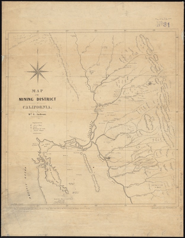
America Transformed: Immediately prior to the discovery of gold in 1848, central California was home to Native communities; Mexican missions, ranchos, and pueblos; the small presidio—fortified military settlement—of San Francisco; and a few white American residents. Published two years later, this map testifies to the frantic pace of settlement during the California Gold Rush. By 1855, over 300,000 immigrants from the eastern United States, Europe, Latin America, Australia, and China established mining camps, towns, and roads. San Francisco grew rapidly. By the 1870s, California’s Native population plummeted from an estimated 150,000 to 30,000. Thousands were forcibly removed from their homelands, enslaved, or killed. Early legislation in California made it lucrative to enslave Native peoples, or to be paid for exterminating them.
- Creator:
- Jackson, Wm. A. (William A.)
- Name on Item:
-
by Wm. A. Jackson.
- Date:
-
1850
- Format:
-
Maps/Atlases
- Location:
-
Boston Public Library
Norman B. Leventhal Map & Education Center - Collection (local):
-
Norman B. Leventhal Map & Education Center Collection
- Subjects:
-
Mining districts--California--Maps
Gold mines and mining--California--Delta Region--Maps
Mines and mineral resources--California--Delta Region--Maps
Delta Region (Calif.)--Maps
California, Northern--Maps
- Places:
-
California
- Extent:
- 1 map ; 43 x 42 cm.
- Terms of Use:
-
No known copyright restrictions.
No known restrictions on use.
- Publisher:
-
New York :
Theodore A. Mudge
- Scale:
-
Scale [ca. 1:592,500]
- Language:
-
English
- Notes:
-
Relief shown by hachures.
Shows drainage, towns, ranches, mines, Indian villages, etc.
- Notes (exhibitions):
-
Exhibited: "America transformed. Part 1: the United States expands westward," organized by the Norman B. Leventhal Map & Education Center at the Boston Public Library, 2019.
- Identifier:
-
06_01_011415
- Call #:
-
G4362.D45 1850 .J33
- Barcode:
-
39999065685842


