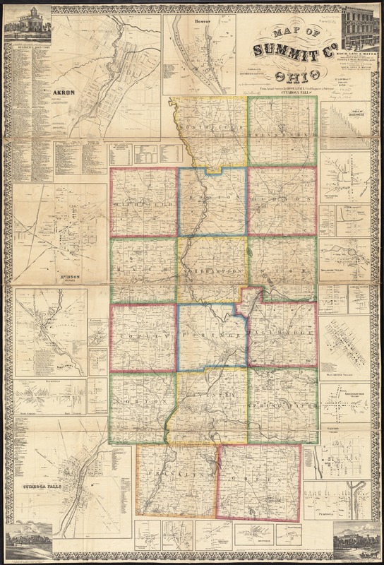
Map of Summit Co., Ohio
Item Information
- Title:
- Map of Summit Co., Ohio
- Creator:
- Paul, Hosea.
- Name on Item:
-
from actual surveys by Hosea Paul, Civil Engineer & Surveyor.
- Date:
-
1856
- Format:
-
Maps/Atlases
- Location:
-
Boston Public Library
Norman B. Leventhal Map & Education Center - Collection (local):
-
Norman B. Leventhal Map & Education Center Collection
- Subjects:
-
Buildings--Ohio--Summit County--Maps
Landowners--Ohio--Summit County--Maps
Real property--Ohio--Summit County--Maps
Summit County (Ohio)--Maps
- Places:
-
OhioSummit (county)
- Extent:
- 1 map on 2 sheets : color, mounted on linen ; 146 x 97 cm
- Terms of Use:
-
No known copyright restrictions.
No known restrictions on use.
- Publisher:
-
Philada. :
Matthews & Taintor,
- Scale:
-
Scale approximately 1:42,240. 1 1/2 inch to 1 mile
- Language:
-
English
- Notes:
-
Includes directories, distance chart, statistics, 24 insets, and 4 views of public, and commercial properties.
Insets: Akron -- Boston -- Hudson Village -- Middlebury -- Richfield -- Tallmadge -- Hammonds Corners -- Bates Corners -- Cuyahoga Falls -- Northfield Village -- Macedonia -- Johnsons Corners -- Montrose -- Stow Corners -- Twinsburg Center -- Darrow Ville, Stow Township -- Ghent, Bath Township --Mogadore Village, Springfield Village -- East Liberty in Green Township -- Copley Center -- Manchester Village -- Greensburgh Village -- Clinton Village -- Peninsula.
BPL copy sectioned into 4 pieces and mounted on cloth.
"Entered according to Act of Congress in the year 1850 by Robert Pearsall Smith in the Clerks Office of the district court of the Eastern District of Pennsylvania."
- Identifier:
-
06_01_011284
- Call #:
-
G4093.S8 1856 .P38
- Barcode:
-
39999065683490
- LCCN:
-
2012592394


