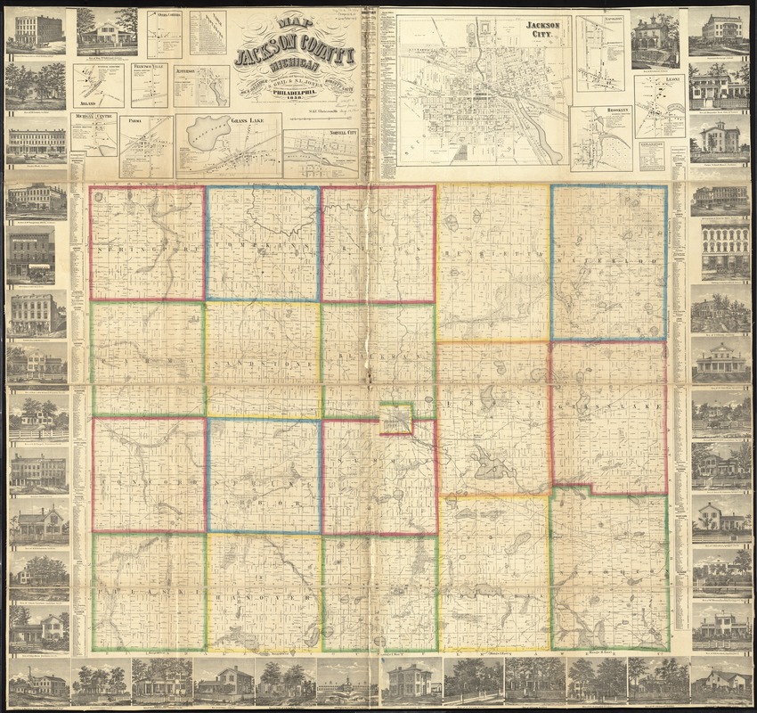
Map of Jackson County, Michigan
Item Information
- Title:
- Map of Jackson County, Michigan
- Creator:
- Geil and Jones
- Name on Item:
-
from records and special surveys by S. Geil & S.L. Jones, topogrl. engineers, engd. & manufd. by Robert P. Smith.
- Date:
-
1858
- Format:
-
Maps/Atlases
- Location:
-
Boston Public Library
Norman B. Leventhal Map & Education Center - Collection (local):
-
Norman B. Leventhal Map & Education Center Collection
- Subjects:
-
Landowners--Michigan--Jackson County--Maps
Real property--Michigan--Jackson County--Maps
Jackson County (Mich.)--Maps
Arland (Mich.)--Maps
Brooklyn (Mich.)--Maps
Francisco (Mich.)--Maps
Grass Lake (Mich.)--Maps
Jackson (Mich.)--Maps
Jefferson (Mich.)--Maps
Leoni (Mich.)--Maps
Michigan Center (Mich.)--Maps
Napoleon (Mich.)--Maps
Norvell (Mich.)--Maps
Parma (Mich.)--Maps
Springport (Mich.)--Maps
- Places:
-
MichiganJackson (county)Brooklyn
MichiganJackson (county)Parma
MichiganJackson (county)Francisco
MichiganJackson (county)Grass Lake
MichiganJackson (county)Jackson
MichiganJackson (county)Jefferson
MichiganJackson (county)Leoni
MichiganJackson (county)Michigan Center
MichiganJackson (county)Napoleon
MichiganJackson (county)Norvell
MichiganJackson (county)Springport
- Extent:
- 1 map : hand colored ; 147 x 155 cm
- Terms of Use:
-
No known copyright restrictions.
No known restrictions on use.
- Publisher:
-
Philadelphia :
Jos. M. Alexander,
- Scale:
-
Scale 1:39,600. 1 6/10 in. to 1 mile
- Language:
-
English
- Notes:
-
Includes distance table, business and patrons' directories, and 38 illustrations.
Insets: Oyers Corners -- Arland -- Francisco Ville -- Jefferson -- Michigan Centre -- Parma -- Grass Lake -- Norvell City -- Jackson City -- Napoleon -- Brooklyn -- Leoni.
"Entered according to Act of Congress by S.L. Jones in the year 1858 in the Clerk's Office of the District Court for the Eastern District of Pennsylvania."
BPL copy assembled, sectioned into 4 pieces and mounted on cloth.
- Identifier:
-
06_01_011313
- Call #:
-
G4113.J2 1858 .G34
- Barcode:
-
39999065683144
- LCCN:
-
2012593154


